 Lake Tahoe West Shore
Transportation and Travel
Lake Tahoe West Shore
Transportation and Travel| Home
Lake Tahoe West Shore
Transportation and Travel |
|---|
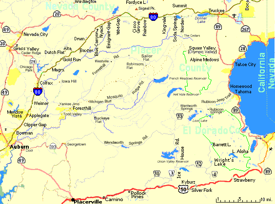
 Davis - Auburn | Zoom Out (Map & directions from airports),
List of locations on this map
Davis - Auburn | Zoom Out (Map & directions from airports),
List of locations on this map
| Location [Exit] |   |
Elev- ation | Popul- ation | Comments |
|---|---|---|---|---|
| Reno Airport off 395 S [65B] | -38 | |||
| Reno [10-16] | -32 | 4498 | 155,499 | Gas, Lodging, Hospital, Food, Shopping Center |
| Verdi [2] (1-3 westbound) | -21.4 | 4905 | Gas, Casino, Food | |
| Nevada State Line (204.6 mi.) | -19 | 4905 | ||
| Hirschdale Rd., Boca [194] | -8 | 5600 | ||
| 267, Lake Tahoe [188B] | -2.5 | Northstar Ski Area, Kings Beach | ||
| 89 North, Sierraville [188A] | -2 | |||
| Downtown Truckee [186] | -1 | same as below | ||
| Truckee, 89 S. [185], Lake Tahoe, Squaw Valley (11.5 mi.), Tahoe City (14 mi.) | 0.0 | 5818 | 9,994 |  , Hospital, Gas, Diesel, Fast
Food, Restaurants,
Convenience Store, Lodging, CHP, Hardware, Shopping Center , Hospital, Gas, Diesel, Fast
Food, Restaurants,
Convenience Store, Lodging, CHP, Hardware, Shopping Center
|
| Donner Park Exit [184] | 1.0 | 5900 | Gas, Diesel, LP Gas, Chain Services, Mini-Mart, Restaurants, Lodging, Camping | |
| Donner Lake [180] | 4.5 | 7239 | Food, Lodging | |
| Rest Area | 8.6 | Restrooms | ||
| Castle Peak [176] Summit Boreal Ridge | 9.1 | 7239 | Food, Lodging | |
| Soda Springs [174] | 11.7 | 6768 | 96 | , Restaurants, Convenience Store, Gas, Diesel, LP Gas, Lodging, Chain Services
|
| Kingvale [171] | 14.8 | 6118 | Mini-Mart, Gas, Chain Services | |
| 6000 ft. | 16 | 6000 | ||
| Rainbow Exit [168] | 17.8 | Restaurant, Lodging, Camping | ||
| Cisco Cisco Grove [165] | 20.7 | 5700 | MiniMart, Restaurant, Gas, Diesel, Chain Services | |
| Eagle Lakes Rd. [164] | 22.0 | Camping | ||
| Hwy 20 [161] | ||||
| Yuba Gap [160] | 25.2 | 5600 | Camping, Phone, Food at campground and Eagle Mtn. Nordic Cntr. | |
| Emigrant Gap | 28.0 | 5140 | 36 | , Phone
|
| Nyack [156] | 29.2 | 5400 | Burger King, Mini-Mart, Gas, Diesel, Chain Services | |
| Blue Canyon Exit [155] | 30.5 | 5284 | Porta-Potty at exit westbound in winter. | |
| 5000 ft. | 23.8 | 5000 | ||
| Drum | 35.1 | 4300 | ||
| Baxter [148] | 37.1 | 3900 | Camping, Phone | |
| Alta [146] | 39.2 | 3590 | 751 | , Convenience Store
|
| Dutch Flat [145] | 40.9 | 3144 | 533 | Gas, Restaurants, Camping, CHP |
| Rest Area | 42.2 | Restrooms | ||
| Gold Run [143] | 42.8 | 3222 | 79 | |
| Secrettown Rd [140] | 46 | |||
| Colfax (Hwy 174), Grass Valley [135] | 50.9 | 2422 | 1,306 | Restaurant, Fast Food, Convenience store, Gas, Diesel, Lodging, Camping, Chain Services, LP Gas |
| Weimar [131] | 54.7 | 2280 | ||
| W. Paoli Ln. [130] | 55.4 | Gas, Diesel | ||
| Heather Glen | 56.5 | 2014 | 1,898 | |
| 2000 ft. | 56.6 | 2000 | ||
| Applegate [128] | 57.8 | 2014 | 1,898 | Gas, Diesel, Lodging, Chain Services |
| Clipper Gap, Meadow Vista [125] | 61.0 | 1720 | 3,067 | Gas (2 mi.) - Porta-Potties in eastbound direction between Clipper Gap and Applegate. |
| Bowman [122] | 63.9 | 1620 | Restaurants, Gas, Lodging, Camping | |
| Foresthill Exit | 64.6 | Fast Food, Restaurants, Gas, Diesel, Lodging | ||
| Auburn (Elm Av.) | 66.2 | Food, Gas, Lodging | ||
| Auburn (Hwy 49) [119] | 66.5 | 1359 | 12,129 | , Hospital, Food, Shopping Center
|
| 1000 ft. | 68.2 | 1000 | ||
| Newcastle [115] | 69.4 | 399 | Gas, Food | |
| Loomis | 74.6 | 399 | 1,284 | Gas, Lodging, Food |
| Rocklin | 77 | 248 | 27,214 | Gas, Lodging, Food, Shopping Center |
| Roseville | 80.2 | 159 | 62,649 | Gas, Lodging, Food, Hospital |
| Sacramento | 98 | 407 K | Gas, Lodging, Food, Hospital
| |
| Davis [] | 112.3 | 60,300 | Gas, Lodging, Food, Hospital | |
| Sacramento Airport off of I-5 N. | 106 | |||
| San Francisco Airport off of 101 S. | 194 |
See Also: I-80 info. for Placer Co. and Nevada Co. at interests.com.
Traveling/Road Conditions:
![]()
I-80 and
Hwy. 89 restrictions
are listed under CalTrans Road Conditions and Mountain Pass Closures Pages.
QuickMap | Mobile App
Highway Information Phones:
1-800-427-7623 or (916) 445-7623
WebCams at magnifeye.com
Radio Updates on AM 1610
Hwy. 50 Corridor - (530) 741-4571 |
Interstate 80 Corridor - (530) 741-5474 |
General Information - (530) 741-4572
Winter Operations Page: Controls - Snow Tires, Traction Devices | Winter Travel Tips | Chain Control Placement Chart
California Traffic Information at the Federal Highway Administration.

Emergency Road Svc. 1-800-AAA-HELP (1-800 222-4357)
Placer Co. Highway conditions at CERES (Calif. Environmental Resr. Evaluation Sys.)
Winter Travel Tips at CalTrans,
The CHP,
Southland Ski Server.
National Weather Svc (NWS):
  7-day forecast:  Blue Canyon,  Soda Springs, Truckee
  Winter Weather Advisory:  Truckee,  West Slope Northern Sierra Nevada
    Current: Blue Canyon, Truckee-Tahhoe,

The Weather Channel: Auburn,  Alta, Emigrant Gap, Soda Springs, Truckee

Intellicast: Soda Springs, Truckee
  Satellite view of west coast

Tahoe Forecasts
Live Cams:Emergency Services and Law/Regulation Enforcement Contacts in the Tahoe Area.
Chains:
(See Road Conditions also.)
Chains are usually required during snow storms. There are 3 kinds of chain
requirements, R2 is the most common.
 R1: Chains required - snow tread tires (see below) allowed.
 R2: Chains required on all vehicles except four-wheel drives with snow tires.
 R3: Chains required - all vehicles - no exceptions.
The California Vehicle Code section 558 defines a snow-tread tire as follows: "A 'Snow-tread tire' is a tire which has a relatively deep and aggressive tread pattern compared with conventional passenger tread pattern". Snow-tread tires can be identified by examining the sidewall of the tire where the letters MS, M/S, M+S or the word MUD AND SNOW have been stamped into the sidewall. All terrain tires are usually allowed. See the Chain Control Page at CalTrans for more.
Chain monkeys are available at the side of the road and will install your
chains for $20, however they cannot sell chains so you must have them with
you or buy them at one of the gas stations along the way.
Map of Chain-On Areas from CalTrans
During a normal storm chains would typically be required from 1 mi. east of Baxter to Truckee eastbound and from Truckee to Kingvale westbound.
During a heavy storm the highway may be closed during the night
with chains required from Gold Run to the Nevada state line in the morning.
Chain requirements may be moved up to Baxter or higher during the
day as the snow level rises. Chains may be required as early as Colfax
during very cold spells when the snow level falls to 2,500 ft. elevations.
Delays
Traffic may be metered at Applegate to avoid congestion at chain
control points further up. On Fri. Jan 2. 2004 there was 1:45 delay (4 mi. backup) starting at Dry Creek Rd. plus another 15 min. delay at Gold Run for chain controls. During winter there are Porta-Potties in eastbound direction between Clipper Gap and Applegate.
The maximum recommended speed with chains is 30 MPH and there can be delays of 3 Hrs. or more due to congestion so adjust your time accordingly. On Jan 1, 2004 the highway was closed for 2 hrs. due to spinouts.
The CalTrans Winter Travel Tips page has more information.
|
Small towns like Baxter and Cisco Grove supported small busineses
while Highway 40 was used, but there is not much left of them now.
With a few exceptions like the Rainbow Lodge, all there is between
Colfax and Truckee are a few gas stations with Mini-Marts and a couple
of restaurants at I-80 exits.
Gas: | |
| Hospitals Sutter Auburn Faith Hospital (530) 888-4500 Emergency (530) 888-4550 (N. Auburn Off Hwy 49 1 block north of Bell Rd.) 11815 Education St. Auburn, CA 95602-2410 | Tahoe Forest Hospital (530) 587-6011 Emergency (530) 582-3206 (off Donner Pass Rd. east from Hwy 89 exit) 10121 Pine Ave. Truckee, CA 96161-4856 |
|
Sutter Roseville Medical Center and Level II Trauma Center (916) 781-1000 One Medical Plaza, Roseville, CA On N. Sunrise (2 mi. N. of Douglas Blvd.) Take Eureka Rd. Exit from I-80 Go SE on Eureka Rd. Left on N. Sunrise for 0.6 mi. to the Medical Center | Renown Medical Center (775) 982-4100 77 Pringle Way at Mill St., Reno, NV |
Other: Visit Placer County page
 other references for more information.
 Hwy 80 at calweb.com
WiWireless Hotspots:
| Place | Location | Provider * | SSID |
|---|---|---|---|
| Truckee (Search) | |||
| Joe Coffee 530-448-3610 | 10120 Jaboom St, Downtown Truckee | ||
| Wild Cherries Coffee House | 11429 Donner Pass Rd, Truckee | Wi-Fi Alliance | exwire |
| Starbucks 530-582-6856 | Gateway Shopping Cntr - 11260 Donner Pass Rd, Truckee | T-Mobil | |
| McDonald's 530-587-3880 | Deerfield Dr (off 89 S.), Truckee | Wayport | |
| Rocktonic Juice - 530-587-9991 | Gateway Shopping Cntr, Donner Pass Rd, Truckee | ||
| Tahoeberry Eatery - 530-582-4535 | 12036 Donner Pass Rd. Donner Lake Exit N., Truckee | ||
| Holiday Inn Express | 10527 Cold Stream Rd Donner Lake Exit, Truckee | ||
| Emigrant Gap | |||
| Colfax +/- 10 mi. (Search) | |||
| Auburn (Search) | |||
| Starbucks | Bell & Highway 49, Auburn | T-Mobil | |
| Starbucks | Lincoln & Foresthill Way, Auburn | T-Mobil | |
| Holiday Inn | 120 Grass Valley Hwy., Auburn | Wi-Fi Alliance | etwireless |
| Rocklin (Search) | |||
| Starbucks | Highway 80 & Rocklin Road, Rocklin | T-Mobil | |
| Five Star Auto Detail | 6818 Five Star Blvd., Rocklin | Wi-Fi Alliance | FiveStarWireless |
| Roseville (Search) | |||
| Starbucks | Cirby & Riverside, Roseville | T-Mobil | |
| Starbucks | Douglas & Sierra College, Roseville | T-Mobil | |
| Starbucks | East Roseville Pkwy & Sunrise, Roseville | T-Mobil | |
| Starbucks | 2030 Douglas Blvd. at Rocky Ridge, Roseville | T-Mobil | |
| Saturn | 750 Automall Drive, Roseville | Wi-Fi Alliance | SaturnWireless |
| It's A Grind Coffee House | 970 Sunrise Avenue, Roseville | Boingo | |
 Wi Fi Zone - free
 T-Mobil - $10/day, $30-40/mo.
 Boingo - $8/day, $22/mo.
 Wi-Fi Hotspots