North Central California
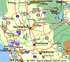
See I-80 Sierra Nevada Page also.
Lake Tahoe Region
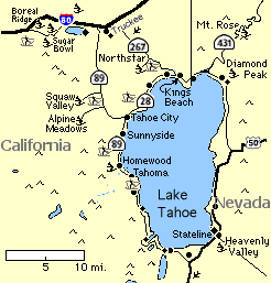
Homewood
From San Francisco Airport (SFO):
From Berkeley start at 3.
- Starting at San Francisco Airport begin on HWY 101 heading north towards San Francisco for 11 miles.
- Continue on I 80 heading east across the Bay Bridge for 8 miles.
- Continue on I 80 northeast 77 mi. to Sacramento and follow signs to Reno. I-80 splits after crossing the Yolo causway between Davis and Sacramento; Stay to the right to bypass Sacramento.
- Continue on I 80 and follow directions from Sacto #2. below:
From Sacramento Airport (SMF):
- Take Airport Exit to I 5 South and go 6 mi. to I80
- Head northeast on I-80 toward Reno for 98.4 mi.
(Auburn is the last large town for a food stop on I-80 before Tahoe. Take the Hwy 49 exit 32.6 miles from I-5 for In-n-Out burgers on the N. side of I80 or continue 2 mi. to the Foresthill Exit. (Follow the frontage road, Lincoln Wy, NorthEast to Sizler, or Burger King or get a hamburger and some fresh fruit at Ikeda's) - Take exit 185, HWY 89 (Squaw Valley, Tahoe City) exit (about 65 mi. from Auburn and 98.4 mi. from I-5) and head southeast for 14 miles to Tahoe City
- Turn right, staying on HWY 89, heading south for 6.5 miles to Homewood.
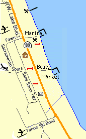
- Cabin at 5255 W. Lake Blvd. is first residence on right past the Homewood Mountain Resort ski hill and woods on the right and West Shore Cafe and High and Dry Marina on the left. Between Fawn and South St.
From Reno. (RNO):
- Starting at Reno Airport, begin on US 395 heading north for 2.7 miles
- Turn left on I-80 W. (Reno) heading southwest for 34 miles
- Exit at 2nd HWY 89 Exit for 89 South Lake Tahoe heading southeast for 14 miles to Tahoe City
- Turn right, staying on HWY 89, heading south for 6.5 miles to Homewood.
Cabin, at 5255 West Lake Blvd., is between Ski Area on right and West Shore Cafe on the left and Rockwood Inn on the right and Obexers on the left. First house past vacant lots on the right.