History
Middlebrook Encampment
History
Middlebrook Encampment
| Don's Home
History
Middlebrook Encampment
|
.
When the 13-star flag was officially adopted by Congress in 1777, the first place it was flown over continental troops was at Middlebrook.
The "Battle of Bound Brook" was fought on April 13, 1777, when Lieutenant General Lord Charles Cornwallis launched a four-pronged attack on the village of Bound Brook.
See Battle of Bound Brook.
After his successful surprise attack against Hessian soldiers garrisoned at Trenton on December 26, 1776 and the battle of Princeton, January 3, 1777 Washington moved his troops to Morristown.
In May of 1777, Washington moved his small army of 8,298 Continental troops men from his winter encampment at Morristown to the Middlebrook Heights, to observe the British troops at New Brunswick and Perth Amboy. Wayne's Brigade, commanded by General Anthony Wayne, from Pennsylvania was camped at the top of the first range of the Watchung Mountains in an area extending west from the intersection of Vosseller Ave. and Hillcrest towards Chimney Rock. They converted the area into a natural fortress. From this mountain, Washington kept an eye on the British in New York and New Brunswick. More importantly , he was in a position to flank the British if they attempted to cross New Jersey to Philadelphia.
At this time General Howe had 17,000 British forces in and about New Brunswick. The Redcoats wereseasoned troops, well trained and equipped.
This caused Howe to have to move his army by sea, causing a delay which prevented Howe from joining Burgoyne, which led to the defeat of Burgoyne's British army at Saratoga in October, the turning point of the of the Revolutionary War. Hence Middlebrook Heights has been called, "The Beginning of the Winning of the War."
In July and Aug. Washington's army move toward Philadelphia where they eventually lost the battle of Brandywine on Sept 11 and the Battle of Germantown on Oct. 4. They clashed again in the Battle of Red Bank in Nov. and eventually retreated to Valley Forge in December. At that time nearly 3000 men of this force were sick or too nearly naked to do duty.
In Nov. 1778 Washington started moving the army back to the Middlebrook area. The Main army, consisting of the Virginia, Maryland, and Pennsylvania Brigades, with the Delaware regiment, the artillery Corps, and the artisans and attached support units, were along the base of the Watchung Mountains. Here they were protected from some of the weather, had a good supply of trees for construction and firewood, and were supported by a generally patriotic population, with an active militia.
Washington set up his headquarters at the Wallace House in what is now Somerville.
The Virginia troops were posted just west of the gap where Middlebrook creek flows out of the mountains, at Chimney Rock. The Virginia position extended along today's Foothill Road. The Maryland Brigade was posted east of the gap, past Vossler Avenue along what is now Middlebrook Rd. almost to Mountain Avenue. The Pennsylvania Brigade were posted south, at Weston, in today's Manville. Several miles north west along the ridge, at Pluckemin, the Artillery Corps was stationed, with an extensive academy/barracks construction
"Possible weak spots in Washington's bulwark, were the two ravines, the Basking Ridge Road [present day Vosseller Ave.] and the Middle Brook gorge [present day Chimney Rock rd.]. The former had a road, but the narrow gorge was almost impassable. Also he had a wide view of the country around New Brunswick, only seven miles awasy, the road to Pluckemin [present day Washington Valley Rd.], and the course of the Raritan. He could watch the British General Howe's movements continually.The observation post was his "Rock" on the south-side cliffs of MiddleBrook Heights. Moreover, he could move his army, blocked from view by the mountain ridge, to either flank of the British camp. He and his men thus formed a constant threat to the British and could harass them almost at will. Eventually Howe was forced to fall back from New Brunswick to Perth Amboy and finally into New York City.
See The Washington Campground Association Page
In 1974, William Liesenbein, performed a archaeological investigation of the same area. He refutes some of Boom's claims that most of the walls were set up for fortifications, but did admit that some may have been. He also found features which he speculates could have been huts and kitchens in 1777.
Ernest Richard Bower - Describes some of his finds in the area described above in Revolutionary War "At the Crossroads", 1999.
In 1973-74, A. A. Boom, a local historian who conducted tours of the area around Miller Lane,
did an extensive investigation of the rock walls in the area, which is documented along with a
history of Washington's army encampments in Chapter 11 of
"North of the Rariton Lotts [sic]: A history of Martinsville, NJ area".
Report on the Middlebrook Encampment by the Continental Army During Middle 1777 Winter 1778-79 - A. A. Boom - Google Books
In 1974, William Liesenbein, performed a archaeological investigation of the same area.
Ernest Richard Bower - Describes some of his finds in the area described above in Revolutionary War "At the Crossroads", 1999.
Kels Swan (1928-2017),former Curator/Historian at Washington Crossing State Park had a wealth of knowledge on local history.
Search for more about Kels Swan
Herb Patullo is a local businessman and leader in local cultural organizations, including
past president of The Washington Campground Association. He is also quite knowledgeable on local history and has created the Eagle's Nest Museum at the end of Miller Lane.
He bought property on the ridge at the western end of the encampment area, to preserve it from development. He lives there and has small museum, the Eagles Nest.
Somerset County added the property south of Miller Ln (from Herbert Patullo and purchases) to Washington Valley Park in the late 1990's.
Maps:
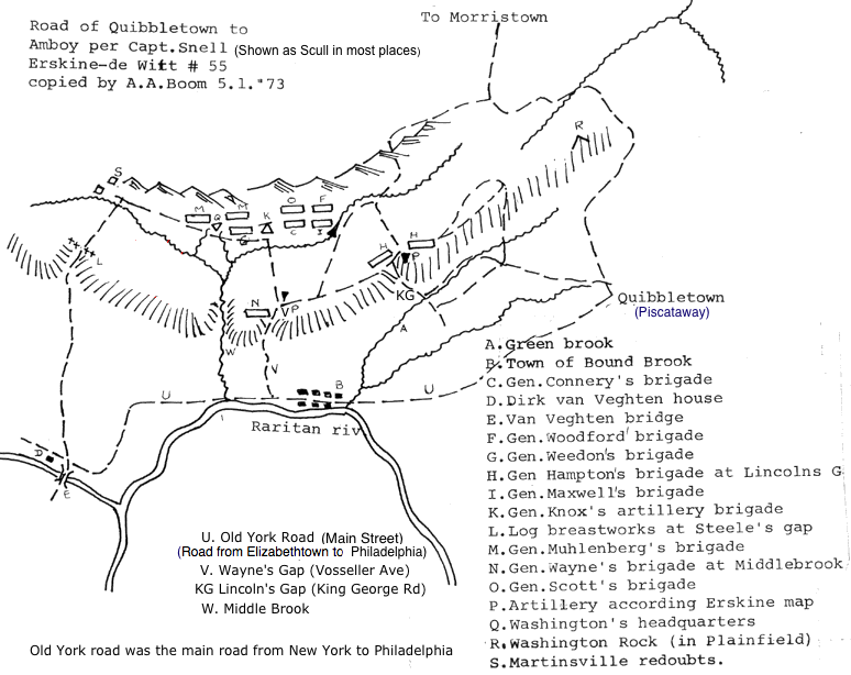
A.A. Boom made the following sketch of the map Captain Snell made for General Washington.
See more about the original.
"Report on a Preliminary Archaeological Investigation of the Alleged Site of the 1777 Summer Encampment
of Wayne's Brigade at Middlebrook, NJ",
Wm. Liesenbein, Tucson AZ, 1974
Liesenbein Map showing stone walls
1777 Scull Map, 1778/9 Angelakos Map,
"Images of America, Somerset County, Crossroads of the American Revolution", William A. Schleicher and Susan J. Winter.
"The Mapping of New Jersey, The men and the art.", J. Snyder, Rutgers University Press, 1973
Other Maps:
1778 Scull Map,
1778/9 Angelakos Map,
Boom Map showing stone walls, Liesenbein Map showing stone walls
Rutgers Cartography Historical Maps
Images of early maps on the web
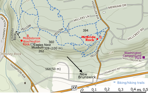
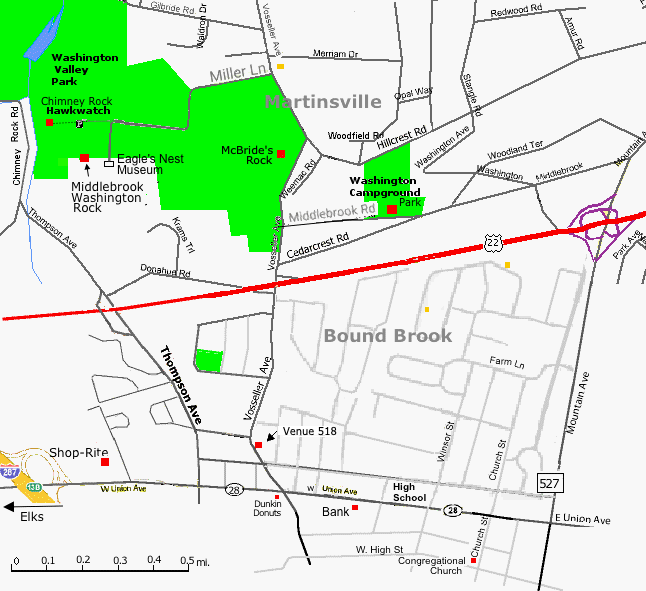
Eagle's Nest Museum
Chimney Rock< - Sight of Washington Valley Hawk Watch
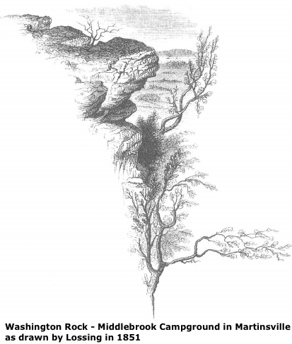
See more about Middlebrook Washington Rock and McBride's Rock
Mayers new book "Revolutionary New Jersey-Forgotten Towns and Crossroads of the American Revolution" was out in June 2018.
See Also:
American Revolution in NJ
Finding the Eagle's Perch | www.GardenStateLegacy.com. - An account of historian Robert A. Mayer's research for
his book.
Article on Forgotten N.J. sites of the Revolutionary War highlighted in Robert Mayers 2014 book | NJ.com
"Middlebrook, The American's Eagle's Nest" by Carl Prince, an 88 page booklet available from the Somerset County Historical Society
Middlebrook Encampment at lincolnbittner.com
Revolutionary War
New Jersey During the Revolution
Revolutionary War "At the Crossroads"
By Ernest Richard Bower
The Middlebrook Winter Encampment of Washington's Army December, 1778 to June 1779 by Glenn Valis.
Washington Valley Park
Watchung Mountains
Bridgewater, New Jersey Revolutionary War Sites | Bridgewater Historic Sites | RevolutionaryWarNewJersey.com
Martinsville History
Somerset Co. History and Historical Associations
An article from the Courier News.
"Watchung author, Bound Brook historian claim to discover another Washington Rock" | MyCentralJersey.com
Middlebrook encampment | Wikipedia
Middlebrook and the Defense of New Jersey | Crossroads of the American Revolution
Bridgewater, New Jersey Revolutionary War Sites | Bridgewater Historic Sites Return to: Martinsville Information