 History
Middlebrook Encampment
Middlebrook Washington Rock
(aka McBrides Rock)
History
Middlebrook Encampment
Middlebrook Washington Rock
(aka McBrides Rock)
(Click on pictures for a larger version)
Originally named McBride's Rock in Robert Meyer's 2018 book, Revolutionary New Jersey: Forgotten Towns and Crossroads of the American Revolution;
Renamed Washington Rock, Middlebrook in Meyer's 2021 book, "Middlebrook - The Revolutionary War Campground that Saved America".
Myers was in the process of writing the 2018 book, where he named an outlook near Herb Patullo's Eagle's Nest Museum, Middlebrook Rock.
Don McBride showed him the outcropping closer to Vosseller Avenue. He agreed that it looked more like the old drawing of the Washington outlook, but it was too late to change the name in the book.
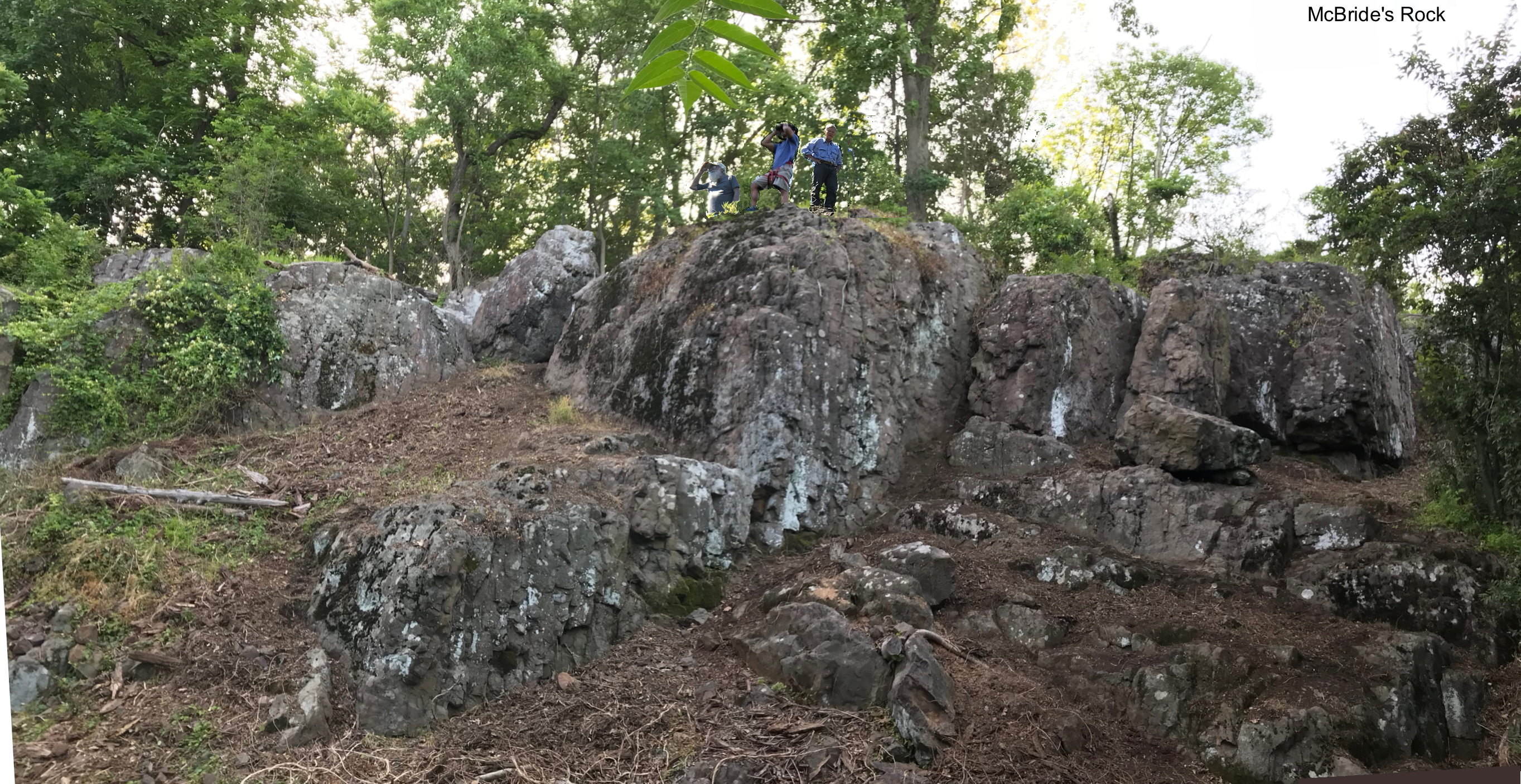
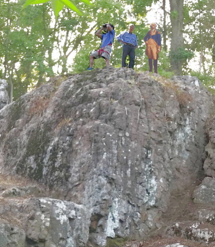 Washington Rock, Middlebrook (aka McBrides Rock) is a newly identified Washington outlook at Middlebrook Heights -- The first range of the Watchung Mountains -- in Washington Valley Park between Vosseller Ave and Chimney Rock Rd. in Martinsvill NJ).Historian, Robert A. Mayers' found documentation of a Washington lookout in Middlebrook in research for his new book, "Revolutionary New Jersey: Forgotten Towns and Crossroads of the American Revolution " (2018). He had found another rock he named Middlebrook Washington Rock to the west, but when I saw the documentation in a presentation he gave I thought it matched a cliff 1/4 mile from my house which I had walked by for 40 years. I guided him thru the woods to show him the view from the 25 foot cliff and he agreed it matched the sketch he had, and it was right where the continental army army was camped next to Wayne's Gap, the road/trail from Bound Brook over the Watchung Mountains, to Morristown where General Washington had his headquarters, so he added a section to the book and named it McBride' Rock.
George Washington used it to watched British General Howe in New Brunswick in 1777 when his army was camped on the ridge above it right where we lived.
See Middlebrook encampment.
The traditional Washington Rock is at Washington Rock State Park in Green Brook (5 miles east of the Middlebrook Encampment). Washington used it when the British moved east towards Amboy (Perth Amboy), Staten Island or New York. He also used it during skirmishes in Quibbletown (now New Market section of Piscataway), Plainfield, Scotch Plains, Woodbridge and Edison, including the battle of Short Hills, which actually occurred at what is now the Plainfield Country Club. Mayers has more about that in his book.
But, when the British were stationary in New Brunswick Washington used the Middlebrook observation point, where his army was camped.
It is a basalt (blue stone) rock cliff near the top of the first range of the Watchung Mountainss near Vosseller Ave in Martinsville (Middlebrook Heights). It is 240 ft above the valley below. It's about 110 ft. wide and the top is 25 feet above the ground at the bottom.
40.5815,-74.5438
(Click on pictures for a larger version)
Background:
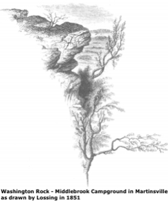
At the Washington Campground Association Meeting in February 2017, Historian, Robert A. Mayers from Watchung gave a talk about the new book he was writing, Revolutionary New Jersey: Forgotten Towns and Crossroads of the American Revolution. He found a description of Middlebrook Heights outlook in famous historian Benson Lossing Pictorial Field-Book of the Revolution or, Illustrations, by pen and pencil, of the history, biography, scenery, relics, and traditions of the war for independence. 1859 Lossing says.
)where George Washington watched British General Howe in New Brunswick. Middlebrook Heights is the Watchung Mountains between Vosseller Avenue and Chimney Rock Road.
He also found a sketch of the rock there.
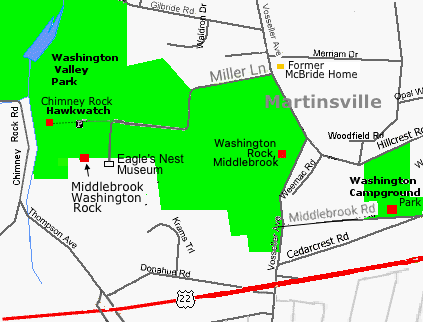
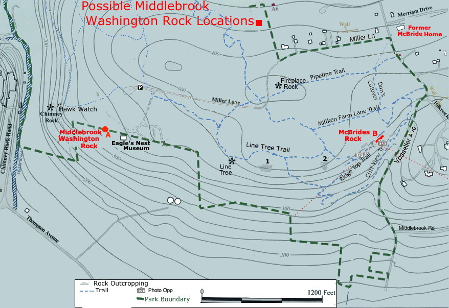
There was another candidate for Middlebrook Washington Rock between Herb Patullo's Eagle's Nest Museum at the end of Miller Lane and Chimney Rock.
Because of easier access and proximity to the museum, Mayers had named it
Middlebrook Washington Rock.
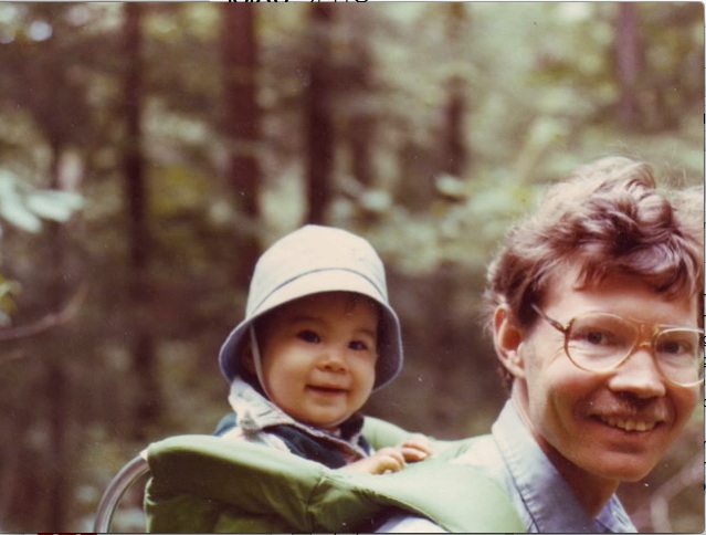 I thought the sketch looked like a rock I had walked by for 30 years. In 1979 I used to take my 1 year old son, Tom, riding in a child backpack, on hikes across Vosseller ave through the woods in the undeveloped Washington Valley Park .
We used to go to the top of a rock cliff at the edge of the first range of the Watchung Mountions a quarter mile from our house and look at the view. I always thought it would be a good place for Washington's troops to keep a eye on the British.
I continued to hike in that area and lead hikes there for the
Raritan Valley Group of the Sierra Club.
I hadn't been by it in years so went over to take a look at it.
It was now a jungle; The rock face was covered with vines, there were downed trees from hurricane Sandy leaning against it and thickets of stickery invasive Japanese barberry at the top and bottom.
A friend, Dave McRitchie, and I pulled down the vines..
I showed Mayers the location nearer Vosseller Ave, which which only the mountain bikers knew about because of the proximity to one of their trails.
 It was a 2/3 mile hike thru tick infected woods from the Chimney Rock parking lot, so most hikers didn't go buy it. The 1/4 mile hike from the corner of Vosseller Ave. and Miller Lane was not on the park service maps.
Mayers admitted there were reasons this rock was the more likely candidate. It was the best match for the 160 year old sketch of the lookout at Middlebrook Heights in his forthcoming book.
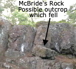
The large boulder in the middle right of the picture above could be the rock outcropping at the top of the sketch which had broken off over the years.
The traditional Washington Rock is at Washington Rock State Park in Green Brook (5 miles from the Middlebrook Encampment).
The Green Brook rock has a view east all the way to New York and is where George Washington went to monitor British Troop movements, when General Howe was moving toward Westfield and Staten Island.
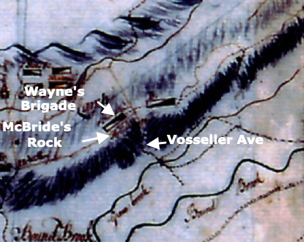
However when Howe was stationary in New Brunswick it makes sense that Washington would have watched them from Middlebrook Heights where his army was camped in 1777. General Wayne's Brigade was camped, according to Captain Scull's map, on the west side of Wayne's gab --now Vosseller Ave --.
Mayers thought he had found Middlebrook Washington Rock, between Herb Patullo's Eagle's Nest Museum at the end of Miller Lane and Chimney Rock.
In the meantime Herb Patullo had expanded his Eagle's Nest Museum near his house at the end of Miller Ln. with an expansive view of the valley below including New Brunswick to include the area around the rock there. There was parking and easy access there, so that location became the official Middlebrook Washington Rock.
In Chapter 6 "Washington Rocks: Perches of the American Eagle (1777-1778)" of his book Revolutionary New Jersey: Forgotten Towns and Crossroads of the American Revolution Mayers has labeled the rock near Vosseller Ave. McBride's Rock.
Google Map 40°34'53.2"N 74°32'37.5"W @40.581450, -74.543750
Note: Trail names are proposed
Eagle's Nest Museum
Line Tree - A tree shaped with 3 forked trunk (fallen now)
Fireplace Rock - Approximate site of Revolutionary War Signal Tower
Chimney Rock - Sight of Washington Valley Hawk Watch
Zoom out to Washington Valley Park.
There is no parking near McBride's Rock. In the summer you can see it from Vosseller Ave. but there is no place to pull over or stop.
You could park at the Chimney Rock parking area and then follow the trails for about 2/3 mile to get there. There is a place to pull off Miller Lane where it bends to the right and follow the trail 1/3 mile to the top of the rock.
From the top of the rock it about 1/4 mile using the trail towards Vosseller Ave. to the trail at the bottom.
Case for McBride's Rock:
In the description of the lookout an Middlebrook heights by famous historian Benson Lossing (See Middlebrook Washington Rock - Lossing)
the Mcbride's rock formations look like Lossing's drawing.
It is a higher elevation (375') vs the chimney rock location (315').
It also fits the Lossing's description "It stands
quite alone, and rises from a slope of the hill, about twenty-five feet".
In "Finding the Eagle's Perch" | www.GardenStateLegacy.com Issue 40 June 2018 Mayers says,
"While Lossing mentions the
Green Brook Rock, residents apparently regarded it as less historically important than McBride's Rock in the years after the war.""
It is closer to the road through Wayne's gap (Vosseller Ave.)
That is where General Wayne's Brigade was camped.
First American Flag:
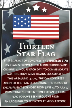 When the 13-star flag was officially adopted by Congress in 1777, the most likely first place it was flown was over continental troops was at Middlebrook.
This plaque is at the Washington Camp Ground, a park half way down the hill where the flag is flown today. But when the troops were at the top of the first range of the Watchung Mountains the flag was most likely to have been flow from this cliff where it could be seen by troops in Bound Brook.
The Hopkinson flag is generally believed to be the first. Francis Hopkinson was a delegate to the Continental Congress from New Jersey and a signer of the Declaration of Independence. The so-called Betsy Ross flag was more likely a flag used for celebrations of anniversaries of the nation's birthday.
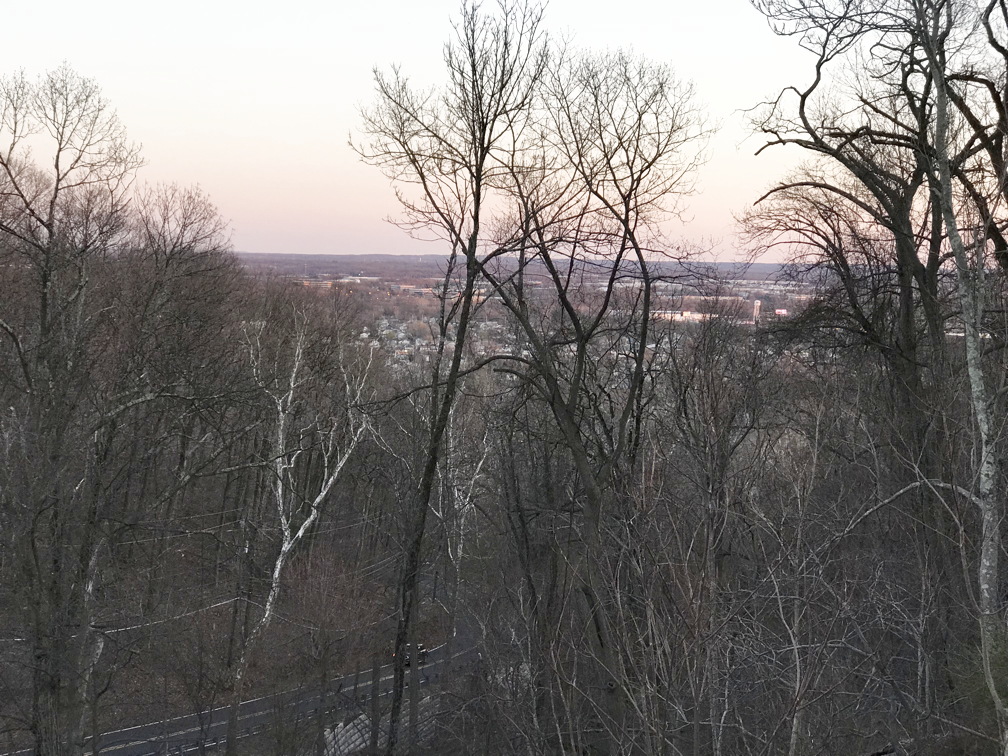
Field of view from McBride's Rock (B) (With some tree cutting done by Washington's Army)
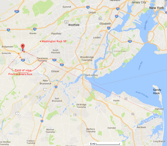
This assumes that some of the trees on the east side of Watchung which obscure the view now would have been removed. (They needed something to keep the troops busy.)
Ancestors in the Revolution:
My McBride ancestors were still in Scotland at the time of the American Revolution, but several ancestors on my Mother's side served in the Continental Army.
Jacob Gard, my 5th Great Grandfather from Morristown, NJ was a captain in the New Jersey Militia. It is possible that he visited McBride's Rock but I couldn't find any evidence of that.
John Jones Sikes (1760-1858) in Massassuchetts served in 1780.
Isaac Thomas served under General Sevier in Tennessee.
More pictures
I did quite a bit of excavating to improve access and kept a lookout for artifacts. The only thing I found was borken piece of a square cobalt blue glass bottle. See archaeology.
Links:
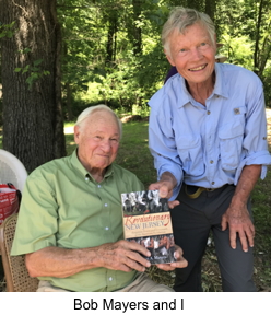
Mayer's article Finding the Eagle's Perch | www.GardenStateLegacy.com
"Middlebrook - The Revolutionary War Campground that Saved America", , 2021 Bob Mayers
Middlebrook and the Defense of New Jersey
Watchung Mountains
Washington Valley Park
Contact
Return to: Middlebrook Washington Rock
Contact: Don McBride -