| Geology of Lake Tahoe and the Sierra Nevada
|
Other References:
Facts and Conservation here

 Geology and Natural History of Lake Tahoe at ceres.ca.gov

 Geological History at LakeTahoeCam.com
 Geology at TahoeThisWeeek
 Timeline
 Geologic Information about California at the USGS
 The Lake Tahoe clearinghouse for geographic (GIS) data
Brief History:
400-365 million years ago (MYA) volcanic eruptions created mountains and granite was formed from molten rock that solidified below the surface).
155-300 million yrs. ago the North American continental plate
drifted away from the super-continent of Pangea and moved westward.
It collided with a Pacific Island chain in an area which is now the Sierra Nevada.
163-143 MYA compression caused uplifting of the Sierra Nevada to about 3/4 of present height.
The primary force creating the lake was uplifting along fault lines
which created the Sierra Nevada and Carson ranges with Lake Tahoe in between
from 4-25 million years ago.
A series of volcanic eruptions added to the landscape 5-25 million
years ago.
The outlet and level of the lake has changed many times. 1-2 million
years ago Mt. Pluto and other volcanos to the north blocked the outlet
near Truckee. A new outlet was cut just east of Mt. Pluto.
More recently (2 million to 20,000 yrs. ago) glaciers blocked the outlet.
The lake has been up to 800 ft. above its present level in the past.
The current outlet at Tahoe City goes into the Truckee River which
flows through Reno to Pyramid Lake where it evaporates.
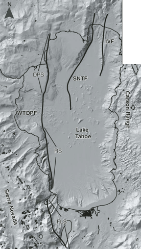
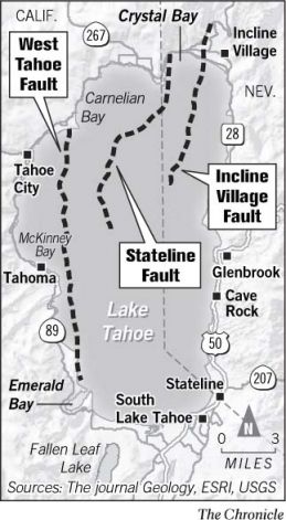
There three faults which can cause earthquakes today.
West Tahoe-Dollar Point fault (WTDPF), Stateline-North Tahoe fault (SNTF), and Incline Village fault (IVF).
Note: I've seen 3 or 4 maps of faults which are slightly different and have different names for the faults, but all
Sources:
(PDF) Paleoseismic history of the Fallen Leaf segment of the West Tahoe-Dollar Point fault reconstructed from slide deposits in the Lake Tahoe Basin, California-Nevada | \0x2002Geosphere - 2013
Holocene subaqueous paleoseismology of Lake Tahoe | Geological Society of America Bulletin - 2013
Reno/Carson Fault Map - Univ. of Nevada Seismological Laboratory - 1997
 The most recent earthquake in the Tahoe region was about 575 years ago, on the Incline Fault, which becomes active about every 10,000 to 15,000 years.
There have been more recent earthquakes north and east of the lake.
The biggest recent quake was on the northern part of the West Shore fault.
In the event of an earthquake move away from windows and doors that face the lake.
The West Tahoe fault may be the most dangerous:
 Earthquakes strike every 3,000 to 4,000 years on the fault.
The West Tahoe Fault last moved 4,500 years ago causing a large part of the west shore shelf to move down into the lake and creating a 30 ft high tsunami.
Actually earthquake-caused large waves in a lake or closed body
of water is called seiche (pronounced say'sh).
Gene Ichinose3 of the UNR seismological laboratory studied the faults underneath the lake and they estimated that the probability of such an event would be around 2-4% in the next 50 years.
See Earthquake Tsunami for more.
Volcanic Peaks: Mt. Rose (10,778'),
Mt. Pluto (8,617'), Mt. Watson (8,424'),
Martis Peak (8,742'), Squaw Peak (8,900'), Mt. Tallac. (9,735')
Throats of ancient volcanos remaining after the outer layers were eroded:
Cave Rock, Eagle Rock, Castle Peak, Mt. Lincoln.
Up-thrown peaks: Freel Pk. (10,881'), Monument Pk.
(10,067'), Mt. Tallac (9,735') * Pyramid Pk. (9,983')
* Mt. Tallac is listed as a volcano in one source and an uplifted peak
in another.
Sierra Peaks Regional Data
Passes
| Pass - Road | Elevation |
|---|
Truckee River - Hwy 89N
Tahoe Outlet | 6,230' |
McKinney-Rubicon Rd.
jeep trail | 7,127' |
| Spooner Summit - Hwy 50E | 7,146' |
| Brockway Summit - Hwy 267 | 7,199' |
| Donner Summit - Hwy 80 | 7,239' |
| Daggett Pass - Hwy 207 | 7,334' |
| Echo Summit- Hwy 50W | 7,382' |
| Luther Pass - Hwy 89S | 7,735' |
Barker Pass
Blackwood canyon Rd. | 7,780' |
| Mt. Rose Summit- Hwy 431 | 8,933' |
Links:
Earthquakes
How Lake Tahoe Was Formed | Cochise College
Geography & History Overview and Facts about Lake Tahoe at the U.S. Geological Survey
How Lake Tahoe Was Formed by Sarrina Cazarez
Return to West Shore Info.