Official Brochure for trip 10175A - "Humphreys Basin High Base Camp, John Muir Wilderness, California"
Start: Official start at 6:30 AM Sunday August 1 at the Packer's station near North Lake.
   Recommended meet up at 5 PM, Saturday, July 31, 2010 at Packers Station
      30 min up CA-168 from Bishop (directions below)
End:   4-6 PM, Saturday, August 7, 2010
Contacts:
Correspondence
Welcome
Questions and Answers (FAQ) Updated
bulletin-1 - Equipment List and Roster
Bulletin-1 revised

Transportation:
Reno is the closest major airport.
  (There is a small airport at Mammoth Lakes)
  Google directions from the reno Reno airport to the packers station. About 5  hrs.

Directions from Bishop to the Packers Station near North Lake:
About 30 min.
From Bishop head west on CA-168 W/W Line St for 18 mi.
Turn right (north) on N Lake Rd. 1.6 mi
Turn right toward packers station 0.1 mi
Google map
We highly recommend that people stay overnight at the packers station (9,000 ft. elevation) Saturday night to get acclimatized. Their contact information is:
If you try to go from sea level over Piute pass at 11,500 you risk getting altitude sickness. [The atmospheric pressure at 11,500' is 2/3 that of sea level] We will set up camp Sat. PM then go back to Bishop for dinner at a restaurant. Jim's pictures at (coyotetrackadventures.shutterfly.com/humphreysbasin) Hikes/Activities: Hikes: Short hikes and swimming at nearby lakes: Packsaddle Lake, 1.5 miles Many other local lakes Day hikes:Distance is round trip except *
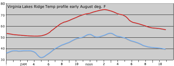
Reference: USGS 7.5: Mt. Darwin and Mt. Tom Inyo National Forest Map Mono Divide High Country Trail Map at Tom Harrison Maps High Altitude Guide Acute Mountain Sickness (Altitude Sickness) Introduction to California Plant Life Trees and Shrubs of California Sierra Nevada Wildflowers Weather: Usually dry, but short thunder showers may occur in the afternoon. Av Temperature Aug: Hi - 68°; Low - 46° Temperature can get below freezing at night.The following links to useful information on the Sierra Club Web site was included in the approval form page.
Links: Southern Sierra Nevada Return to California Basecamp trips
| |||||||||||||||||||||||||||||||||||||||||||||||