 Technology
Mapping
Technology
Mapping

Geographic Coordinate Systems
Defenitions at: www.fgdl.org/tutorials/howto_reproject/Definitions.htmlPreferred by State Governmenets: Geographic (Latitude/Longitude or Decimal Degrees) Universal Transverse Mercator (UTM) State Plane Coordinate System (SPCS) Other Albers Equal-Area Conic Projection - Used by the USGS in their 1970 National Atlas.
Lambert Azimuthal Equal-Area
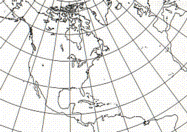
Lambert Conformal Conic
Glossary
- DEM
- Digital Elevation Model (USGS)
- DGPS
- Differential GPS 3-5 m. accuracy
- DLG
- Digital Line Graph
- DOQ
- Digital Orthophoto Quadrangles
- DQQ
- Digital Quarter Quadrangle
- DTM
- Digital Terrain Model (USGS)
- DXF®
- is the Drawing eXchange Format from AutoCAD
- GIS
- - Geographic Information System - A system of hardware, software, and procedures for drawing and analyzing maps and data referenced by spatial or geographic coordinates. Becoming a standard for government projects.
- GPS
- Global Positioning System (Tutorial at trimble.com)
- HPGN
- - High Precision GPS Network High Accuracy Reference Network (HARN) or High Precision Geodetic Network (HPGN) - HARN and HPGN are both names for the same project that is focused on readjusting the NAD83 datum to a higher level of accuracy state by state.
- NAD27
- North American Datum 1927 - State Plane Feet -
- NAD83
- North American Datum 1983 - State Plane Meters -
- NAPP
- National Aerial Photography Program (USGS)
- NDOP
- National Digital Orthophoto Program (USGS)
- NGS
- - National Geodetic Survey - Defines and manages a national coordinate system. This network, the National Spatial Reference System (NSRS), provides the foundation for transportation and communication; mapping and charting;
- NADCON
- - the federal standard for NAD27 to NAD83 datum transformations within the United States.
NADCON conversions between datums are approximate values based on models of real data. A regular grid of control points whose datum shifts are known is used to estimate the shift at other locations. A minimum curvature-derived surface based upon the National Geodetic Reference System determines the transformation of points and introduces approximately 0.15 meters uncertainty (at the 67% confidence level) within the coterminous United States.4 The accepted national standard, NADCON is the fastest, simplest, and most accurate datum transformation for mapping at scales of 1:200 and smaller.
NADCON only converts geographic (latitude and longitude) coordinates. The method cannot be applied directly to projected coordinates, such as State Plane.
See ftp.ngs.noaa.gov/pub/pcsoft/nadcon/readme.txt
NADCON software is available at: https://www.ngs.noaa.gov/PC_PROD. - NOAA
- - National Oceanic & Atmospheric Administration
- NSRS
- National Spatial Reference System
- NRCS
- - U.S. Natural Resource and Conservation Service (gis.itc.nrcs.usda.gov)
- SPCS
- State Plane Coordinate System
- SDTS
- Spatial Data Transfer Standard
- TVP
- Topological Vector Profile
- USGS
- - U.S. Geological Survey - Federal source for science about the Earth, its natural and living resources, natural hazards, and the environment.
- UTM
- - Universal Transverse Mercator
- WAAS
- Wide area augmentation system (or sites) for GPS (< 3m. accuracy)
- WGS 84
- World Geodetic System - Used by GPS systems. Adopted from NAD 83. For all practical purposes there is no difference between WGS 84 and NAD 83.
Map Symbols
Areview symbols at https://www.mapsymbols.comMaps
See Also:
Nautical Charting & Navigation at NOAALocation and Mapping in smart phones and tablets
US Public Land Survey System (PLSS) - Township and Range
Sources:
North Carolina GIS Technical Advisory Committee Position Paper
Return to Don's Home.