Under Construction 
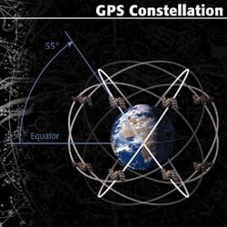 When people talk about "a GPS," they usually mean a GPS receiver. The Global Positioning System (GPS) is actually a constellation of 27 Earth-orbiting satellites (24 in operation and three extras in case one fails). They circle the globe at about 12,000 miles (19,300 km), making two complete rotations every day.
See GPS
A GPS receiver's job is to locate four or more of these satellites, figure out the distanc to each, and use this information to deduce its own location. This operation is based on a simple mathematical principle called trilateration.
The accuracy of a position determined with GPS depends on the type of receiver. Most hand-held GPS units have about 10-20 meter accuracy. Other types of receivers use a method called Differential GPS (DGPS) to obtain much higher accuracy. DGPS requires an additional receiver fixed at a known location nearby.
2015 Reviews:
See Biking GPSs
Handheld - Hiking GPS:
| Model | price | screen
size in | Rating | | Comments |
| OGL | OGL
bike | REI | Amazon | idealo |
| Garmin Oregon 600 | $400 | 3.0 | 86 | | 3.8 (16) | 3.8 (148) | 83 | | EC2 - OGL |
| Garmin Oregon 600t | $480 | 3.0 | | | 3.8 (5) | | | | |
| Garmin Oregon 650 | $480 | | | | 3.9 (7) | | | | |
| | | | | | | | | |
| Garmin Oregon 650t | $550.00 | 3.0 | | | 3.7 (9) | 3.8 (148) | 94 | | |
| Garmin GPSMAP 62sc | $399 | 2.6 | 81 | | | 4.2 (499) | | | |
| Garmin GPSMAP 64s | $300 | 2.6 | | | 3.5 (10) | 4.2 (122) | 90 | | |
| Magellan eXplorist 710 | $405-500 | | 66 | | | 3.0 (68) | | | |
| DeLorme inReach Explorer | $380 | | | | | 4.0 (220) | | | EC backpacker |
| DeLorme Earthmate PN-40 | $170 | 2.2 | | | | 3.5 (214) | | | |
| Satmap Active 12 | | 3.5 | | | | | | | |
| Satmap Active 10 Plus | | 3.5 | | | | | 4 |
| Garmin Montana 650t | $600.00 | 4.0 | | | 4.4 (16) | 4.0 (159) | | | |
| Garmin eTrex 30x | $100.00 | 2.2 | | | 3.4 (16) | | | | |
| Garmin eTrex Legend | | 2.0 | | | | | | | |
1. Rating: score (reviews). - OutdoorGearLab Aug, 2015; REI; Amazon,
idealo.co.uk
2. EC - Editors choice
More on handheld GPS:
The Best Handheld GPS | OutdoorGearLab Aug 2015
Handheld GPS buyers guide - GPS Tracklog 2015
The Best Hiking GPS of 2015 - Best Hiking
GPS Receivers: How to Choose - REI Expert Advice
Cheap Motorcycle GPS - How to Make One Using an iPhone for Under $150 - OutdoorGearLab.com Mar 2015
SmartPhone GPS and Map apps
2006 Reviews
Sources:
Portable car navigation Systems (Recommended by Consumer Reports Dec. 2006)
Portable (Internal battery for use out of car)
| Model | Price | CNET Score |
|---|
| Garmin Nuvi 350 | $800 | 8.3 |
| Magellan RoadMate 760 | $700 | 7.7 |
| Garmin StreetPilot 2730 | $850 | xx |
| TomTom Go 300 | $500 | xx |
| TomTom Go 700 | $700 | xx |
| Garmin StreetPilot i5 | $350 | 7.7 |
Hiking: (usually don't give directions)
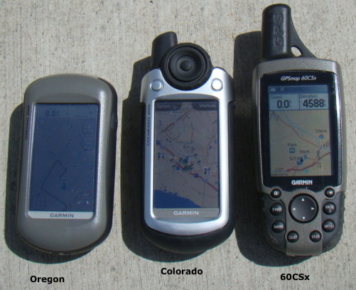
| Garmin™ GPSMAP 60CSx® | $350 | eBay reviews 4.5 |
| Garmin™ Oregon 450 | $400 | |
| Garmin™ Oregon 550t | $600 | |
| Garmin™ Colorado 400t | $600 | |
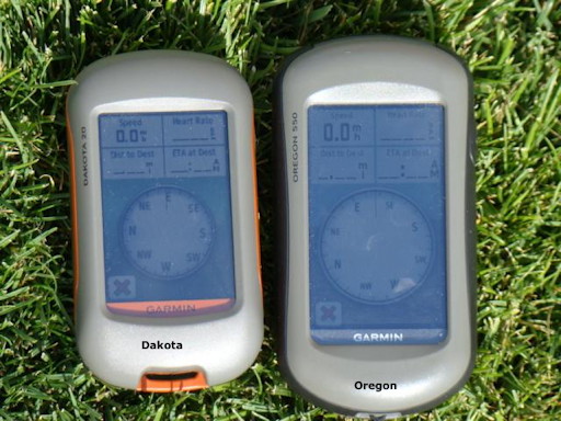
| Garmin™ Dakota 20x® | $300 | eBay reviews 4.5 |
| 2007 reviews |
| Magellan eXplorist 500 | $300 | eBay reviews 4.5 |
| Garmin™ eTrex Legend® Cx GPS | $300 | eBay reviews 4.5 |
| Garmin™ eTrex Venture® | $ | eBay Review 4.5 |
| Garmin GPSmap 60C | $500 | eBay reviews 4.5 |
| Garmin GPSmap 76 | $310 |
| Magellan eXplorist XL | $449 |
| Magellan Meridian gold | $300 |
| Magellan Meridian platinum | $300 |
Notes:
The primary two companies that appeared to be at the forefront of the industry are Garmin and Magellan.
Garmin has a much larger and more diverse product line.
the Magellan MapSend Direct Route software the first street routing software designed specifically for recreational GPS handhelds.
I read that the color display is easier to read in daylight.
CSx designation on Garmin - C: color; S: built in compass (drain's batteries); x: microSD memory card.
In early 2009, it appears that Garmin stopped using the SiRFstar III chipet due to a patent dispute, substituting a MediaTek (MTK) chipset. While both are high-sensitivity chipsets, Garmin is still fine-tuning the MTK firmware. The switch to this chipset has reduced one of the advantages the 60/76 C(S)x series has enjoyed over newer Garmin models.
Ratings:
idealo.co.uk
Retrevo - GPS product advisor
GPS Tracklog: Garmin Dakota 20 , Garmin eTrex Vista H, Lowrance Endura Sierra review, Garmin GPSMAP 60CSx | GPS Tracklog
Garmin Dakota 20 review | GPS Tracklog
Dakota 20 8/10
Garmin Dakota 20 First Impressions and Review
a smaller version of Garmin's successful Oregon models
Size: 2.6 Inches / Resolution of Main Display: 160 x 240 Pixel
Better visability in sunlight than Oregon.
Much poorer sunlight visibility than eTrex.
GPSMAP 60CSx
2.6 Inches / Resolution of Main Display: 160 x 240 Pixel
Garmin Dakota 20 vs GPSMAP 60CSx:
In useability, the Dakota is leaps and bounds ahead of the 60CSx. Not only because of the touch screen vs. several different buttons and a directional rocker switch, but also because of a vastly improved user interface. One example of the advantages of the touch screen is the ability to drag maps around instead of having to use the arrow keys. And text entry with a touch screen compared with arrow keys is far faster. An example of the improved UI is having all the settings in one place instead of context menus under each screen.
Dakota has the same screen size but is smaller overall.
Visibility: Screen is not as clear as the 60CSx but readable. found the visibility/brightness on the D20 to be suitable for most types of lighting, including in the sun and in the dark
The Dakota does have more track noise and variation in location than the Oregon, posibly due to a smaller antenna.
Performance - The Dakota feels significantly faster. Maps redraw very quickly, startup times are fast, and menu commands are nearly instant. The unit powers on and is ready to use in under ten seconds.
Source: https://www.greatwallforum.com/forum/gps-information/1204-gps-receiver-testing-garmin-dakota-20-a.html
Sources:
Portable car navigation Systems (Recommended by Consumer Reports Dec. 2006)
The screen is not as readable in the sun with the touch screen models (Oregon and Dakota) as with the older versions.
Areas where you may have difficulty garnering reception are very dense forests, slot canyons, caves or downtown Manhattan.
Handheld GPS buyers guide - GPS Tracklog
Maps:
Reviews at travel-map-software-review.toptenreviews.com
TOPO USA (DeLorme)
Software is brimming with clever off-road mapping features - including customization tools that help you easily create 3-D elevation profiles, examine distances and grade for your next trip. The program is not GPS compatible but with a serial port connection to your laptop, you can get real-time tracking in your automobile.
Once you go through the painless process of creating an elevation profile, you are given stats pertaining to that profile, such as climbing distance, grade, elevation gain, descending elevation and more.
MapSend (Magellan)
Uses National Elevation Data from the United States Geological Survey (USGS) to create it's 3-D images for the most reliability possible.
Although the elevation data is comprehensive, the MapSend customization tools are not as good as TOPO USA.
The best part about this program is the points of interest. MapSend Topo 3D includes POI for food and entertainment, as well as a huge database of topography related The POI.
MapSource (Garmin)
Easy to use and includes an automatic route generator and turn-by-turn directions. However, it does not include the customization tools that DeLorme or Magellan offer such as draw tools and 3-D images.
Like Garmin's MapSource City Select, MapSource Topo includes over five million POI, but unfortunately, few of these have anything to do with rural or outdoor type travel.
MapTech
Terrain Navigator software, the most sophisticated topographic software available, comes free with each Maptech USGS Topographic series CD. Software features inclued an electronic GPS interface for uploading/downloading coordinates, distance and area calculations, ...
Garmin MetroGuide USA
TOPO! (National Geographic)
National Geographic (NG) bought this from Wildflower Productions. The Tahoe and Surrounding Areas set I got in 1999 appeared to be scanned versions of USGS topo maps. The navigation and zooming software was nice, but the maps didn't even have the Pacific Crest Trail. I called NG in 2006 and they said they had not updated it and I should get the printed version, which did not have the same level of detail. REI appears to be using these maps in their topo map print kiosks.
2007 forum at hWildSnow.com/
Great review! Hey, have you seen the new Magellan Triton line of GPS units? Looks like the first units that allow direct downloading from NG TOPO maps all the way down to 1:24,000 level. Plus allows you to include all 5 levels of maps provided on the TOPO software. Takes an SD card so you can throw 2GB in there and load it up. I've got the model 500 on order for Christmas, they say mid-Dec shipping.
EZE, I've not seen the new Triton but am testing the Delorme version of a topo map GPS -- their Earthmate. Delorme's uses vector maps (computer drawn contour lines) so it's quite different than having raster maps such as those public domain USGS government sourced topos that National Geographic uses. I like the raster maps better, but the vector maps load faster and take up less space. All super interesting. WildSnow will be reviewing the Delorme unit in a few weeks (if we like it).
Comparison of different types of devices
Comparison of iPhone and Garmin
accuracy (m)/satelites
| Type | In woods
accuracy | Open |
| Garmin forerunner 405 watch | 3 | 7/9 |
| Garmin Legend C | 13 | 6/6 |
| iPhone w/ geocaching.com app | 20 | |
Source: GPS Accuracy - iPhone vs Garmin Forerunner 405 vs Garmin Legend C - YouTube
Comparison of Android and Garmin
Type
Samsung Galaxy 7
Glossary:
See GPS in technology
On-line catalogues:
GPSdiscount.com
FadFusion.com/
Maps:
Garmin DVD vs SD card
The 60csx has no internal memory - everything is stored on a card in a single map file which must contain all the combined mapsets on the unit. The DVD would be preferable for this unit, since you can't add more maps to a pre-loaded card (or, at least, it would be risky to do so IMO) - Ed. I know someone who accidentally wiped out his maps this way.
I would lean toward the card for the 62s, Oregon and Dakota; in fact I have the 24k Northeast topo on a card.
The card has the advantage being usable in as many different units as you like (but only one at a time) while the DVD will become locked to the first unit you install it on. Previously, an advantage of the DVD was that you could use the maps on your computer. This can now be done with the card as well, using BaseCamp.
Interface Equipment:
- PIC On Screen Display (OSD) GPS Video Overlay Unit at BlackBoxCamera.com. Will overlay text from a 4800bd NMEA GPS signaal onto the composite video signal from any camera or other video source.
Books:
GPS Made Easy
About GPS:
CNET Reviews - GPS buying guide
Car GPSs | Hiking and trekking GPS - CNET Reviews | GPS units for road and trail
GPS Information & Receiver Performance Reports at US Forest Service
GPSInformation.net
GPSReview.net
GPS'
at SD Schools
travel-map-software-review.toptenreviews.com
www.gpsinformation.org
GPS Software at WorldWideGPS.com
Which GPS do I buy? at TravelByGPS.com
FAQ - GPS Basics at the FAA
www.geocaching.com
Satellite Navigation & Positioning Laboratory (SNAPlab) at the University of New South Wales.
Maps and GPS information. (maps-gps-info.com)
How GPS works
Precision Farming Tools: Global Positioning System (GPS) with Glossary at Virginia Tech
Links:
Biking or Bike GPSs
gps for hiking, hiking gps, handheld gps, handheld gps units
GPS Receivers: How to Choose - REI Expert Advice
Longitude and Latitude U.S.
Personal Locator Beacons
Handheld GPS buyers guide - GPS Tracklog
Trimble - GPS Tutorial
How Does GPS Work? at the National Air and Space Museum
USDA Forest Service Global Positioning System: GPS Information and Receiver Performance Reports (2000)
GPS4US.com/
Map Coordinate Systems
GPS under tech
GPS Apps for your smartphone or tablet
Geocaching under recreation
Return to Products
last updated 12 Aug 2015
|  Products