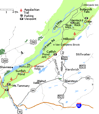
Map of Van Campens Glen, Racoon Ridge, AMC Mohician Center
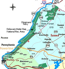
Delaware Water Gap National Recreation Area GPS Coordinates
Geology:
Comparative Graptolite Biostratigraphy Of The Jutland Klippe To The Martinsburg Formation At Delaware Water Gap National Recreation Area
Delaware Water Gap: Structure, Topography and History
Hikes:
NJ - NY Hikes at localhikes.com:
Mt Tammany - Delaware Water Gap Views - Delaware Water Gap Views, Portion of the AT, nice and refreshing stream
Sunfish Pond - Delaware Water Gap - Great Views of Delaware Water Gap., Glacial Pond., lots of wildlife, well maintained trail system, Appalachian Trail
Mohician Outdoor Center, Blairstown
Sunfish Pond:
Maps at:
National Park Svc.
Buttermilk Falls at localhikes.com
Sunfish Pond and Mt. Mocihan Route Map map at gorp
localhikes.com
kicks-ass.org/hiking/DelawareWaterGapFall1997.shtml
Blue Mountain Lakes:
Take Exit 12 on Route 80. Drive into Blairstown on Route 521 North.
Turn left at the Route 94 junction 0.3 mi.
Right at the traffic light take left fork onto Bridge St. (602)
Proceed up steep hill, make right at stop sign, High St
Quick left onto County Road 602 [towards Millbrook (Natl. Rec Area), NOT Stillwater].
Take 602 for approximately 7 miles to Millbrook Village (mile marker 6.2) [41.073158, -74.96373, N41ˇ4.38948, W074ˇ57.8238].
Right at Millbrook Village and go about 1.5 miles to the Blue Mountain Lakes sign.
Turn right, travel a short distance and look for the parking area on the left.
See also:
Northwest New Jersey Skylands Guide
Outdoor Destinations in Northwest New Jersey
Canoeing the Delaware River
Interactive Map - Appalachian Trail Conservancy
favorite hikes at the hiking and camping page
Delaware Water Gap National Recreation Area (U.S. National Park Service)
delawarewatergap.com
Appalachian Trail Information:
Maps list
gorp.away.com
NY-NJ Trail Conference - Map
Appalachian Mountain Club
Appalachian Trail of New Jersey
See Also:
Highlands
Skylands
New Jersey and New York City area Hiking
Central North NJ
|  NE New Jersey

 Interactive Map at Yahoo, MapQuest