NE New Jersey North West AMC Mohican Outdoor Center
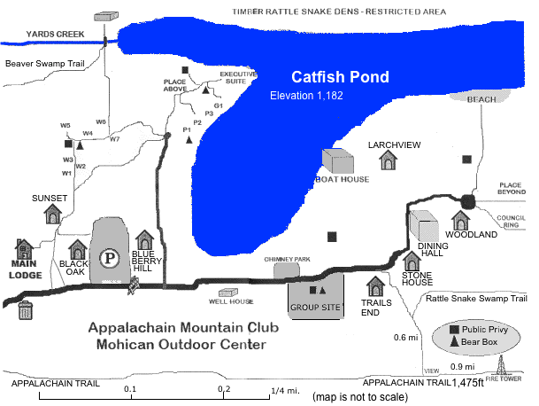
50 Camp Rd., Blairstown - 908-362-5670 - mohican@mindspring.com
Reservations: 603-466-2727 (9AM - 5PM, Monday-Saturday) or online.
You can rent a cabin for the weekend and get meals in the Lodge.
A local group of folk singers usually shows up Saturday nights for informal entertainment open to the public.

mohician outdoor center, catfish pond
Google Satellite Map     Zoom Out - Map below

Mohician Outdoor Center at AMC NY - North Jersey (outdoors.org)
Mohican Outdoor Center at NJskylands.com
Catfish Pond
Racoon Ridge has a hawk watch in the Fall

AMC - Mohican Outdoor Center - Recommended Local Hikes

Directions:
See: AMC: Lodging - Directions to Mohican
Map at North West NJ

  • I-80 to to Route 521 North (Exit 12, Hope, N.J.). Take the right fork of the exit and follow signs for Blairstown.
  • Take Route 521 North to Route 94 and turn left to head south.
  • Take Route 94 South for 1.1 miles through Blairstown to Mohican Road and turn right on Mohican Road.
  • Follow Mohican Road 3.5 miles to Gaisler Road.
    CAUTION: This is a winding road with several forks; always bear right at the forks.
  • Turn left and take Gaisler Road for 1/2 mile.
  • Turn right onto Camp Road (just before the "Children Playing" sign).
    Camp Road turns into a dirt road.
  • Cross the Appalachian Trail.
  • You will come to an unlocked gate; drive through.
  • When you see the lodge on the left and a double garage on the right, stop, park, and come in to the lodge to register.
Driving time from
New Brunswick  1:30     Morristown     1:05
Bridgewater    1:20     New York City  1:30-2:00
Trenton        1:55     White Plains   1:55
Get directions from your location 
Maps:
mohician outdoor center, catfish pond, Kaiser Trail, Rattlesnake Swamp Trail, Fire tower, Racoon Ridge, Van Campens Glen, Copermine Trail, Appalachian Trail
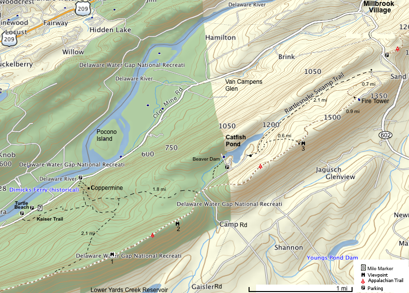
Zoom out - Delaware Water Gap National Recreation Area   Click on map for larger version
Rattlesnake Swamp loop to AT and Fire tower and back to Rattlesnake S trailhead. 4.5 mi. 600 ft. elevation gain.
Gps Coordinates:
Viewpoint 2 41.02598899975419 -75.008825026452541 
Coppermine E.Trail Head lat="41.032134024426341" lon="-75.005635963752866"
Kaiser Trail Trailhead to Racoon Ridge (google)
North West NJ
Hikes near Millbook NJ (pdf) at nps.gov
Hikes: Van Campens / AT / Millbrook NJ at nps.gov
Hikes at Coppermine Area NJ (AT spurs) at nps.gov Delaware Water Gap National Recreation Area at nps.gov

Links:
Delaware Water Gap National Recreation Area - Plan Your Visit (US NPS)
Interactive Map - Appalachian Trail Conservancy
Kaiser Trail/Raccoon Ridge at NJ Birding and Wildlife Trails


last updated 22 Nov 2010