|
Day 1: Met at the Clair Tappaan Lodge (CTL) at 4 p.m. for orientation.
After dinner Francy demonstrated the essentials for backpacking and tips for reducing pack weight .
Spent the night there at an elevation of 6,960 to get acclimatized.
Day 2: Drove to the Pacific Crest Trail (PCT) trailhead off I-80 at Boreal Ridge/Castle Pk
and hiked to Flora Lake, 1.5 miles.
Thunder and lightning rolled in just as we got to Flora L, so we had to practice our lightning safety. See https://donsnotes.com/recreation/lightning.html
Some people went back to the cars at the PCT trailhead and others went cross country back to CTL, 2.5 mi [330 ft elevation gain]. Topo
We went back to CTL, where we practiced setting up tents.
We had to look up a youtube video to figure out one of the tents with a more complicated pole configuration. [Lesson: don't wait till you get out in the woods before trying out your tent.]
After Dinner we visited a local petroglyph sight for a talk by a Forest Service Ranger.
Day 3: After breakfast we drove across I-80 to the Lola Montez trailhead and hiked approximately 3.5 miles Lola Montez (7,160') [gross elevation gain 705']. where we cooked a gourmet dinner consisting of variety of items Francy had dried herself.
Topo Map.
Day 4: After breakfast, some people attempted to find the old trail to upper Lola Montez. We got to an overlook of Lower Lola Montez after a scramble up some rocks [320 ft vertical]. Total 2 mi. round trip.
Departed camp and hiked 3.5 mi. [200 ft net vertical] back to our cars and a shower and beds at CTL.
 Day 5: After breakfast, we drove back to the PCT trailhead where we started on day 2 and hiked north up to Peter Grubb Hut at 7,800 ft. 4.5 miles [680 ft vertical]
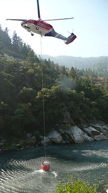
We watched the forest service helicopter search for some of the 22 fires started by the lightning storm on Monday and pick up a bucket of water from Castle Creek in Round Valley (Picture to right is from the web not Round Valley), a short distance from our camp. A group of firefighters got out and headed off into the woods.
After dinner Laura took some of us on a wildflower tour in Round Valley and then up on the ridge above the hut to watch the sunset.
Topo Map.
Day 6: Layover day.
We hiked to Sand Ridge Lake, 3 miles round trip, with about 240 ft. of elevation loss and gain in each direction.
Topo Map.
Day 7: After breakfast, we broke camp and backpack back to the trailhead. Return to CTL for lunch and an opportunity to shower before heading home.
last updated 11 Aug 2012
| 