
Current Conditions:
Weather can't be forecast more than a week or so in advance, but weather averages are good indicators of what to expect any month.
Weather forecasts don't necessarily agree and can differ by 10°. The Weather Channel seems to be the best.
Current Conditions:
Weather Chnl: Tahoe City, Lake Tahoe
The Weather Underground: Tahoe City, Soda Springs
WeatherCentral: Tahoe City
AccuWeather: Lake Tahoe |
Soda Springs
NWS: Tahoe City (forecast.weather.gov) (click on map for specific location)
Precipitation season % of normal at NWS:
Snow depth:
Air Temperature:
Tahoe basin Precipitation:
Soda Springs
LINKS:
Links:
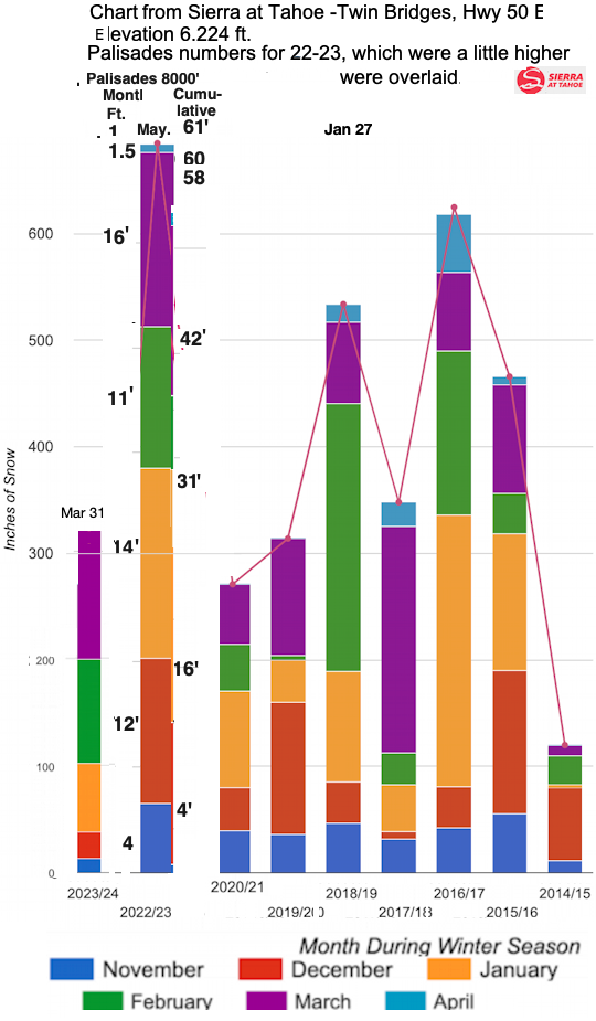
See more about snow on the snow page.
Lake Tahoe, Truckee River/Soda Springs/Mt Rose
See Snow Page
Fire Restrictions (Tahoe NF, Tahoe Basin
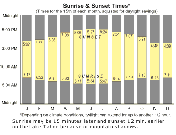
Lake Tahoe
Temperatures - Tahoe City
Month Oct Nov Dec Jan Feb Mar Apr May Jun Jul Aug Sep
weather-us.com
Avg. High °F 59° 47° 40° 39° 41° 45° 50° 60° 69° 77° 77° 69°
Avg. Low °F 32° 25° 20° 19° 20° 24° 27° 33° 39° 45° 45° 40°
2011 weather.com Avg. High °F 60° 48° 41° 40° 42° 45° 51° 60° 69° 78° 77° 70°
Avg. Low °F 32° 26° 21° 20° 21° 24° 28° 34° 40° 45° 45° 40°
Record Low 9° 1° -16° -14° -15° -6° 5° 9° 24° 22° 35° 21°
Year 1971 1931 1972 1937 1989 1935 1999 1974 1982 1975 1942 1965
Avg. Precip. (in.) 2.0 4.2 4.7 6.0 5.7 4.6 1.8 1.2 0.8 0.3 0.5 0.9
Snowfall:
Temp is ° F. - Snow Depth is inches
- Tahoe City 1917-2007 at the Western Regional Climate Center
Avg. snowfall (in.) 2.5 16 35 43 38 35 16 4 0 0 0 0
Avg. snow depth 0 2 10 21 30 27 13 1 0 0 0 0
Snow - South Lake Tahoe at USA Today
Avg. snowfall (in.) 3 17 34 44 37 36 15 4 0 0 0 0
Avg. snow depth 0 3 11 21 30 28 14 2 T 0 0 T
Snow - Squaw Valley Lodge 1955-75
Avg. snowfall (in.) 4.3 24 47 55 50 36 22 8 0.3 0 0 0.6
Avg. snow depth 0 4 19 33 44 40 21 3 0 0 0 0
Snowfall - Squaw Valley Mountain 2003-2008
Avg. Snowfall 0 40 123 74 57 91 67 8 0 0 0 0
Source: Temp. -Weather Channel (Tahoe City) ; Snow Depth - S Tahoe at USA Today; Snow - Squaw Valley Lodge at the Western Regional Climate Center
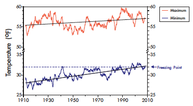
From 1910 to 2008 average Daily minimum temperature at Tahoe City has increased by more than 4 degrees F, and daily maximum temperature has risen by less than 2 degrees F.
Source: TERC State of the Lake 2009
varies by location. The Sierra rain shadow causes yearly precipitation to decrease as one moves east. Donner summit in the north and Echo summit in the south can get 80 in. per year. Carson City over the mountains to the east gets only 25 in. per year. Precipitation ranges from 40 inches per year (in/yr) on the eastern side to 90 in/yr on the western side according to the 1999 USGS Fact Sheet.
According to the Tahoe Environmental Research Center (TERC)
From 1910 to 2008, average annual precipitation (water equivalent of rain and
snow) was 31.6 inches. The maximum was 69.2 inches in 1982. The minimum was 9.2 inches in 1977. 2008 was the 12th driest year on record, with only 19.3 inches of precipitation.
Recent Years:
1910-2008 av. 32 in
1995-1999 av. 50 in
2000-2004 av. 26 in
2005 38 in
2006 48 in
2007 20
2008 19

See:
1999 USGS Fact Sheet 035-02
TERC State of the Lake
Soda Springs data at The Weather Channel and accuweather
Month Oct Nov Dec Jan Feb Mar Apr May Jun Jul Aug Sep
Avg. High °F 60° 46° 39° 39° 42° 46° 52° 61° 70° 78° 77° 71°
Avg. Low °F 26° 20° 14° 14° 16° 20° 24° 29° 34° 37° 37° 32°
Record Low 7° -10° -28° -21° -33° -9° -3° 10° 18° 24° 25° 16°
Avg. Precip. (in.) 2.2 4.3 4.4 4.9 5.6 5.2 1.3 1.5 0.6 0.5 0.6 1.2
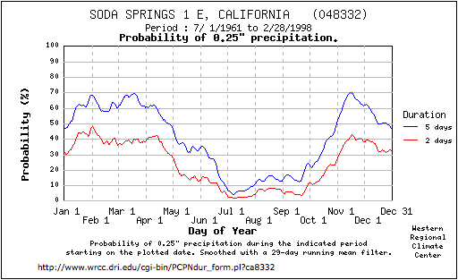
Snow - Soda Springs 1961-1998
Avg. snowfall (in.) 0 52 53 104 57 77 51 13 0.7 0 0 0
Avg. snow depth 0 3-18 18-45 40-80 80-100 90-105 90-50 50-10 10-0 0 0 0
Similar data is available at the Western Regional Climate Center.
They did not have data for Soda Springs, similar lows occurred at Boca.
Created from data at Natural Resources Conservation Service (NRCS.usda.gov)
Northern California GCA at the National Weather Service by the U. Utah
Tahoe National Forest Snow Report
Sierra Avalanche Center
Western Region Climate Center at the Desert Research Institute (DRI)
Northern California Map with stations
Averages at the Weather Channel
5-day precipitation forecast from noaa.gov
Weather Chnl: Lake Tahoe, Tahoe City
weather central.
Current Conditions from the Forest Service
USA Today: Tahoma
Pacific Coast Satellite
Yahoo
Natl Weather Svc Storm Warnings
Weather Page at Ski Homewood
NWS Weather Reports weather.noaa.gov:
Emigrant Gap, Blue Canyon I-80 and Truckee South Lake Tahoe
El Nino theme page
Snow Report Links and Ski Area Closing dates on the Ski Page
At USA Today
Snow Reports at SkiLakeTahoe.com/
At SkiCentral
Snow accumulation at: Weather Underground,
National Weather Service 5/15/2006 National Operational Hydrologic Remote Sensing Center (NOHRSC)
Weather CAMs:
At USA Today,
North Shore near Kings Beach.
bThe World's Deepest Snow (PHOTOS) - weather.com