Geology
Grand Canyon Village (South Rim) and local trails
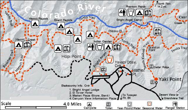 Section of Backcountry map at Natiional Park Svc (NPS) | Area Map (Whole Canyon) | Other Maps
South Rim Trails
Bright Angel Trail  
| |
South Kiabab Trail
|
| Destination | Dist.
1 way | Vert. | Time
Rnd. Trip | Av.
Grade | Destination | Dist.
1 way | Vert. | Time
Rnd. Trip | Av.
Grade |
| Indian Garden | 4.6 | 3,060 | 6-9 hr. | 13% | Cedar Ridge | 1.5 | 940 | 2-4 hr. | 12% |
| Plateau Pt | 6.1 | 3,120 | 8-12 hr. | 10% | Skeleton Pt | 3 | 2,040 | 4-6 hr. | 13% |
| River | 7.8 | 4,460 | * | 11% | River | 6.3 | 4,860 | 8-11 hr. * | 15% |
| Bright Angel Camp | 9.3 | | | | Bright Angel Camp | 6.8 | | |
| Phantom Ranch | 9.6 | | | | Phantom Ranch | 7.2 | | |
| * You should not try to go to the river and back in 1 day according to the Park Service. |
|
Hermit Trail
| |
Grandview Trail
|
| Destination | Dist.
1 way | Vert. | Time
Rnd. Trip | Av.
Grade | Destination | Dist.
1 way | Vert. | Time
Rnd. Trip | Av.
Grade |
| Santa Maria Springs | 2.2 | 1,680 | 5-8 | 14% | Horseshoe Mesa | 3.2 | 2,600 | 6-9 hr. | 15% |
| Dripping Spring | 3.25 | 1,680 | 6-9 | 10% |
| Hermit Creek Camp | 7.7 | 3,660 |
| Hermit Rapids Camp | 9.2 | 4,280 |
Inner Canyon Average Temperatures
|
JAN |
FEB |
MAR |
APR |
MAY |
JUN |
JUL |
AUG |
SEP |
OCT |
NOV |
DEC |
| High (F) |
56 |
62 |
71 |
82 |
92 |
101 |
106 |
103 |
97 |
84 |
68 |
57 |
| Low (F) |
36 |
42 |
48 |
56 |
63 |
72 |
78 |
75 |
69 |
58 |
46 |
37 |
See NPS Weather Page for more.
Sources: NPS Hiking Info - Day Hikes (South Rim Day Hikes), Backcountry Trail Information, "Backcountry Trip Planner"
Note: Skeleton Point on the S. Kiabab Trail has the best views for your effort.
Trips to the river and rim to rim hikes usually require 2-3 days.
The most common routes include one night at Bright Angel Camp near the river and a night at Indian Garden. You need reservations (see below) for camping. Rim to Rim hikes usually start at the north Rim because it is higher. Mule trips stay overnight at Phantom Ranch.
* Although the Natl. Park Service (NPS) warns you not to try and hike to the river and back in 1 day, experienced hikers do the loop, S. Kiabab down and Bright Angel Back, in the Spring and Fall when it is not too hot. It takes an experienced hiker in good condition from 8-11 hrs. including a 1 hr. lunch break. (add 1/2 hr. to go to Phantom Ranch where you can get a beer and snacks
at the canteen with has a swamp cooler.) See: A Grand Canyon Day Hike
Topo Maps: Bright Angel Trail | South Kibab Trail,
3D Maps.
Note: The NPS has the following warning at their Backcountry Trail Information page.
"There are an average of 400 search-and-rescue incidents in the Grand Canyon backcountry every year; the majority involve people on their first hike in the canyon. Remember, there are no easy trails into or out of the Grand Canyon."
In addition to steep trails dangers include ice thru March and heat (over 100° F at the bottom from June - Aug.)
Guidelines
- Time: The Park Service says inexperienced hikers should allow twice as long to return (uphill) as it takes to go down. Experienced hikers usually take from 1.2 - 1.5 times as long to go uphill with a day pack.
- Food & water: Take 1/2 - 1 qt. of water for each hour spent hiking (1 Gal. for a long day hike.) Salty snacks help replace electrolytes lost through perspiration and prevent Hyponatremia (nausea, confusion, frequent urination).
- Rest: Take a 10 min. break at least every hour. Don't hike in the lower canyon during mid-day during the hot summer months.
There have been many water pipeline breaks in the Phantom Ranch area, so it is a good idea to carry water purification tablets with you, in case you need to get water from the creek.
See:
Index to Hiking Info (Tips for the trail, Hiking Safety Information, Facts and Warnings - e.g. Temperatures in the SUN are normally 120 to 140 Degrees Fahrenheit inside the canyon. The lower you go the hotter it gets.)
General Information
See www.nps.gov/grca/grandcanyon/trip_planner/general_information.htm for General Information at the NPS.
- Most of the Grand Canyon lies within Grand Canyon National Park and is managed by the National Park Service. It includes 277 miles of the Colorado River. It is the 3rd largest National Park, 1,217,000 acres, in the continental US behind Death Valley and Yellowstone (Several in Alaska are larger).See Quick Look.
- It has the second most visitors, 5 Million/year, of any National Park, behind the Great Smoky Mountains National Park.
- It is 10 miles across (rim to rim) at the Grand Canyon Village and 18 miles at its widest. At its deepest, it is 6000 vertical feet.
- Best Sunset - Hopi Point. See Sunset TImes.
- Best Day hike (Strenuous) - Skeleton Point (4-6 hrs.) via. South Kiabab Trail.
- Temperatures in the inner canyon are about 20° F higher (av. 106° in July) than those at the south rim because of the elevation difference (2,400' vs 7,000'). The North rim is over 8'000'.
- Swimming in the Colorado River is not recommended as currents are very powerful and water temperatures are below 50° F.
- Roads to the North Rim are closed in the winter. They are normally open from mid-May thru mid-Oct.
- Day Hikes do not require permits.
- Reservations required for: (See Trip Planning)
- Camping - Permits issued on the first of the month 4 mos. prior to date of trip. a few permits for the following day may obtained starting at 8:00 AM at the back country office.
- Phantom Ranch (dormatory and cabin space)- 23 mos. in advance.
- Mule trips - 11 mos. in advance. 1 day part way to river and back. 2 day with overnight at Phantom Ranch.
- Lodging - 6 lodges (4 on the rim) run by Xanterra at Grand Canyon Village and a variety of hotels at Tusayan on Rt. 64 at the South Park Boundary. See www.grandcanyonlodges.com/ or call (888) 297-2757 for Xanterra reservations. You usually need reservations a year in advance for the Rim Lodges during the summer and 3 mos. in advance for the other lodges.
- River Running - There are a variety of companies providing 7-18 day trips thru the Grand Canyon. Shorter trips on the Colorado River are available outside the Grand Canyon.
- Best Food - El Tovar Hotel
Information at:
Natiional Park Svc (NPS) -
Backcountry Info
Fodors, Excite
GrandCanyonHiker.com
Reservations at: www.grandcanyonlodges.com/ and www.grand-canyon.com .
Grand Canyon at: American Park Network
Hiking Grand Canyon National Park $15 at Trails.com
Purchase Grand Canyon Topographic Map by Trails Illustrated $10
Links:
Geology:
The Grand Canyon How it was made - video
Search for Grand Canyon Geology
Return to Arizona
last updated 9 Apr 2003
|
 Places


