 Places
California
Southern Sierra Nevada
Yosemite
Places
California
Southern Sierra Nevada
Yosemite
| Don's Home
Places
California
Southern Sierra Nevada
Yosemite
|
Source: WallPaperHill.com
Contents:
Inroduction | Planning - What to Do | Fall with Kid| Accommodations | Geology | Photography | Waterfalls | Hiking | Climbing | Maps
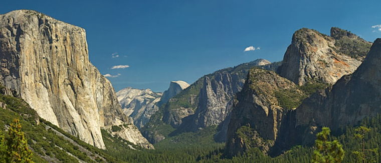
Yosemite National Park was established on 01 October 1890, and is the Nation's third oldest national park. Yosemite National Park is a showcase of spectacular geological features, including the greatest concentration of granite domes in the world and the largest exposed granite monolith in the world.
Most people think of Yosemite Valley with granite monoliths like Half Dome and numerous waterfalls.
The valley is surrounded by Yosemite National Park, a 1,200 square mile park containing deep valleys, grand meadows, ancient giant sequoias, a vast wilderness area, and much more.
The Tuolumne Meadows Visitor Center on Hwy 120 (Tioga Rd.) 10 miles west of the 9,945 ft Tioga Pass, has information on day hikes and wilderness permits.
Yosemite was the birthplace of the idea of the Sierra Club. There is a famous picture of Sierra Club founder, John Muir and Presedent Theodore Roosevelt at Glacier Point in 1903.
John Muir's did as much as anyone to promote Yosemite, bringing notables such as Theodore Roosevelt and Ralph Waldo Emerson to visit.
Visit Planning - What to do:
Yosemite Tours | Tour Yosemite | Plan a Tour of Yosemite National Park | yosemite.com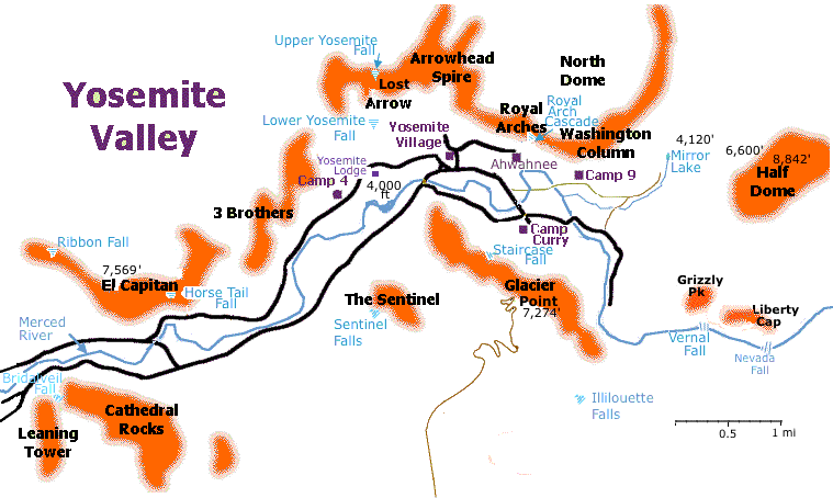
Derived from Climbing in Yosemite at Guillaume and Jennifer Dargaud's website.
See more map links below.
Yosemite National Park is a showcase of spectacular geological features, including the greatest concentration of granite domes in the world and the largest exposed granite monolith in the world.
Ansel Adams photographs have done much for the parks notoriety.
It is the sixth most visited National Park with 4 million visitors a year.
Yosemite Trip Planner | National Park Trips - Outside | MyYosemitePark
Things to Do | TravelYosemite.com
Guided Bus Tours
Valley Floor Tour. 2 hours Yosemite rangers $39
Yosemite Falls, Half Dome, El Capitan, Tunnel View, Bridalveil Fall and more.
Yosemite Grand Tour. 8hrs. Not in 2022
One Day in Yosemite | An Amazing 1 Day Yosemite Itinerary | TravelMadMum
Best things to do.
hike to lower yosemite falls
Upper falls is good but time consuming
Mirror lake loop
Tunnel View
Mariposa Grove
Sentinel Dome
Glacier Point
Dinner at the Ahwahnee
GyPSy Guide audio tour $10
Yosemite National Park (nps.gov/yose): Yosemite Valley
Current Conditions
Yosemite National Park Vacation | YosemitePark.com
What to Do at Yosemite - National Geographic
Rock Climbing
Half Dome Day Hike (U.S. National Park Service)
See Hiking below:
There are many photography workshops available, see:
Yosemite Landscape Photography Workshops
Yosemite Photo Walk - Yosemite Photo Tour : Yosemite Park
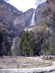
Waterfalls in the Valley:
Yosemite Falls is the second highest waterfall in the world at 2,425 ft, if you count all three sections. Only Angel Fall (3,300 ft) in Venezuela is higher.
The Ahwahnee guest list included Dwight D. Eisenhower, Haile Selassie, the Shah of Iran, Herbert Hoover, Eleanor Roosevelt, Will Rogers, Gertrude Stein, Charlie Chaplin, Will Rogers, Lucille Ball, Ronald Reagan, Walt Disney, Greta Garbo, John F. Kennedy, and most recently Queen Elizabeth II and Prince Phillip.Tenaya Lodge at Yosemite, Fish Camp – Updated 2022 Prices
Source: Architecture in the Parks (The Ahwahnee) at nps.gov
Geology:
Geology:
400-365 Million years ago (MYA) magma which cooled underground (Igneous rock) formed the granite.
155-300 MYA the North American continental plate drifted away from the super-continent of Pangea and moved westward. It collided with a Pacific Island chain in an area which is now the Sierra Nevada.
163-143 MYA compression caused uplifting of the Sierra Nevada to about 3/4 of present height.
As the mountains rose, the land tilted and the westward flowing Merced River accelerated, carving deep, v-shaped river canyons. Later, massive glaciers flowed down the canyons.
2 million to 20,000 yrs. ago colder temperatures slowed melting and eventually glaciers formed and began to carve away at the v-shaped canyons, transforming them into u-shaped valleys. Tributary streams did not carve their canyons as deep as Merced Canyon. Glaciers sheared off these canyons leaving them as "hanging valleys." Tributary creeks, which had once joined the main stream at the same elevation, now plummeted off of shear cliffs, giving birth to the park's famed waterfalls. Eventually, sediment washed down out of the high country, filled in Lake Yosemite to form the present valley floor.
| Falls | Heigh | Dates * | Peak |
|---|---|---|---|
| Yosemite Falls | 2,425 ft | November through July | May |
| Sentinel Falls | 2,000 ft | March through June | May |
| Ribbon Fall | 1,612 ft | March through June | May |
| Horsetail Fall | 1,000 ft | December through April | |
| Bridalveil Fall | 620 ft | All year | May |
| Nevada Fall | 594 ft | All year | late May |
| Vernal Fall | 317 ft | All year, though by mid to late summer, it narrows and separates into one, two, or three falls as water flows decrease; | late May |
| Illilouette Fall | 370 ft | all year. Widest falls. | late May |
Horsetail Fall is famous for appearing to be on fire when it reflects the orange glow of sunset in mid- to late-February. It falls off of the east side of El Capitan and is best seen from just east of El Capitan.
See:
Yosemite National Park - Waterfalls (U.S. National Park Service)
How much water will there be in the Yosemite waterfalls?

Horsetail Fall
Climbing:
Yosemite is world renown for its rock climbing. See the Rock Climbing page here
Yosemite Valley Plan 199?
Reduce parking spaces from 1,700 to 550
2003 legislature proposal to increase back to 1,200 and add campsites.
Communication:
Cell:
Eastern Yosemite Valley includes Yosemite Village
AT&T: Voice and 3G (4G HSPA+) data and voice, primarily in eastern Yosemite Valley
T-Mobile: Yosemite Valley: 4G LTE and voice, primarily in eastern Yosemite Valley
Verizon: 4G LTE and voice, primarily in eastern Yosemite Valley, El Portal
4G LTE data service and voice
Internet:
Complimentary WiFi is available at Degnan's Kitchen in Yosemite Village(bandwidth is limited).
Mariposa County Library
Ahwahnee for guests only
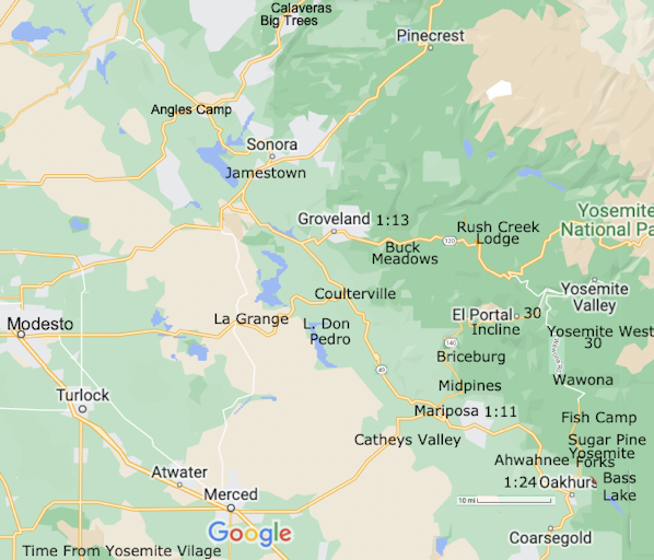
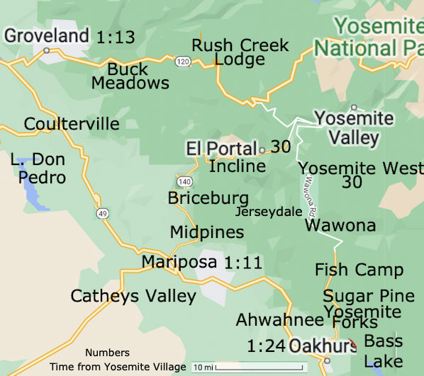
Maps:
(click on maps for a larger version)
Yosemite National Park - Maps (nps.gov/yose): Yosemite Valley |
Hiking Trails
Yosemite National Park (www.nps.gov/yose/)
Google Map of the National Park
Google Terrain Map of Valley
Yosemite Valley Topo
Tioga Road/Big Oak Flat Road - Map