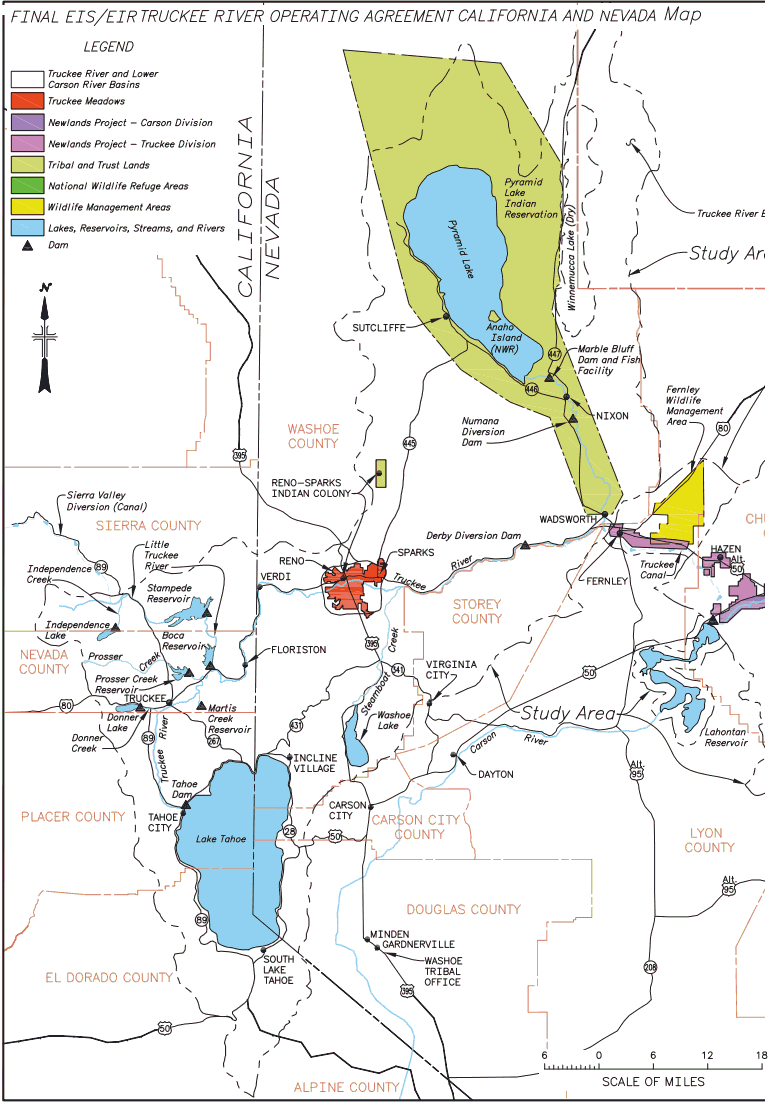
The Truckee River starts at the outlet from Lake Tahoe at Tahoe City goes north to Truckee, then north-east to Reno and ends in Pyramid Lake north-east of Reno.
Several streams feed into the River between Truckee and Reno. It is 108 miles long.
Total precipitation at Tahoe City for the water year (October 1 - September 30) is projected to be 26 in for 2012.
Mean annual precipitation is 31 in. The middle quartile values are from 21 - 43 in.
Flow is controlled by the dam at the Lake Tahoe Outlet in Tahoe City.
Flow is adjusted based on several factors.
Minimal water supply for Reno
Controlling Lake Tahoe Level.
2016-2017 Season - Record Snowfall
After years of drought the level was at the rim 6,223.
The maximum level so piers are usable and lakefront property is not flooded is 6,229.1'
In the middle of May, 2017 the lake was up to 6,227.7', so there was only 1.4' to the maximum level.
Projected rise from snow melt thru early August was projected to be 2.7', so water was being released at the maximum rate to avoid overflowing bridges and other problems.
See
High water on the Truckee River Explained | Video from Placer County Emergency Manager
USGS Current Conditions for USGS 10337500 TRUCKEE R A TAHOE CITY CA
Table 3-1. Selected Upper Truckee River Basin Truckee River Inflows Above the Farad Gaging Station
(Average Annual Runoff Volumes in Acre-Feet [Flow Rates in Cubic Feet per Second])
| Gaging Station Location | Average-Water Year (af [cfs]) | Low-Water Year (af [cfs]) | High-Water Year (af [cfs]) |
| Lake Tahoe Outlet (at Tahoe City) | 161,450 [223 cfs] | 110 [0.15 cfs] | 832,570 [1,150 cfs] |
| Donner Creek (at SR 89) | 60,890 [84.1 cfs] | 18,750 [25.9 cfs] | 102,800 [142 cfs] |
| Martis Creek (below Martis Dam) | 19,470 [26.9 cfs] | 5,000 [6.90 cfs] | 53,940 [74.5 cfs] |
| Prosser Creek (below Prosser Dam) | 65,950 [91.1 cfs] | 17,660 [24.4 cfs] | 154,930 [214 cfs] |
| Little Truckee River (below Boca Dam) | 123,800 [171 cfs] | 40,250 [55.6 cfs] | 340,270 [470 cfs] |
| Bronco Creek (at Floriston, California) | 9,920 [13.7 cfs] | 4,400 [6.06 cfs] | 15,420 [21.3 cfs] |
Source: Farad Diversion Dam Replacement Project - Chapter 3 - Hydrology, 2002
Mean annual precipitation in the Tahoe basin is 31 in. The middle quartile values are from 21 - 43 in/year.
Assuming runoff is proportional to precipitation this means that about 25% of the time all the water entering the lake would be lost to evaporation, so output to the Truckee River is restricted and the lake level will be lower at the end of the year.
Outflow to the Truckee River is adjusted to keep the water level within these limits. However, there are minimum flows to supply water for Reno and maximums to avoid flooding in Reno.
See the Floristion Rule
According to the Truckee River Chronology at nv.gov, Oct, 2011, Truckee river outflow can range from 110 acre-ft [0.15 cubic ft per sec (cfs)] to 832,570 acre ft [1,150 cfs].
The minimum according to another source is 70 cfs.
Mean monthly flows (cfs) in the Truckee River at Donner Creek based on model results in wet, median, dry, and extremely dry hydrologic conditions. Shaded boxes indicate when recommended minimum flows of 75 cfs are not met.
Source: Truckee River Riparian Vegetation and Fluvial Geomorphology Study, 1993
| Wet | Median | |||||||||||||
| Apr | May | Jun | Jul | Aug | Sep | Oct | Apr | May | Jun | Jul | Aug | Sep | Oct | |
| CC | 1577 | 1552 | 1256 | 547 | 442 | 455 | 340 | 623 | 778 | 518 | 173 | 110 | 223 | 260 |
| NA | 1504 | 1516 | 1252 | 543 | 441 | 458 | 347 | 602 | 762 | 517 | 174 | 112 | 226 | 270 |
| LVNA | 1504 | 1516 | 1252 | 543 | 442 | 458 | 348 | 603 | 763 | 516 | 174 | 112 | 228 | 271 |
| TROA | 1534 | 1546 | 1293 | 544 | 329 | 307 | 309 | 621 | 805 | 551 | 215 | 118 | 137 | 202 |
| Dry | Extremely Dry | |||||||||||||
| Apr | May | Jun | Jul | Aug | Sep | Oct | Apr | May | Jun | Jul | Aua | Sep | Oct | |
| CC | 275 | 289 | 158 | 90 | 68 | 89 | 23 | 227 | 253 | 133 | 63 | 26 | 44 | 5 |
| NA | 273 | 282 | 158 | 89 | 67 | 73 | 29 | 229 | 253 | 130 | 60 | 24 | 34 | 12 |
| LWSA | 273 | 282 | 158 | 89 | 66 | 72 | 31 | 229 | 253 | 130 | 81 | 24 | 32 | 14 |
| TROA | 272 | 391 | 247 | 105 | 68 | 61 | 41 | 201 | 260 | 142 | 64 | 22 | 35 | 21 |
CC - Current Condition
NA - No Action
TROA - Truckee River Operating Agreement
LWSA - Local Water Supply Alternative
Source: Truckee River Operating Agreement usbr.gov, 2008
Table 1. Statistics for major reservoirs in the Truckee River Basin.
| Reservoir Name | Storage (Acre-Feet) | Drainage Area (mi2) | Date dammed | Elevation | Function(s) |
| Lake Tahoe | 744,6001 | 506 | 19132 | 6227 | Storage for instream flow and irrigation |
| Donner Lake | 9,500 | 14 | 1930s3 | 5900 | Municipal and irrigation water supply |
| Martis Creek | 20,300 | 40 | 1971 | 5760 | Flood control |
| Prosser Creek | 29,800 | 50 | 1962 | 5680 | Flood control, instream flow, water conservation in Lake Tahoe |
| Independence Lake | 17,500 | 8 | 19394 | 6300 | Municipai supply |
| Stampede Reservoir | 226,500 | 136 | 1970 | 5760 | Pyramid Lake fish flows and flood control |
| Boca Reservoir | 41,100 | 172 | 1937 | 5600 | Municipal and irrigation water supply |
2. The first dam was constructed in 1871 or 1874
3. Original dam was constructed in 1877
4. Small dam originally constructed in 1879
Source: Truckee River Riparian Vegetation and Fluvial Geomorphology Study, 1993
Links:
Truckee River Operating Agreement TROA.net
Truckee River Operating Agreement usbr.gov, U.S. Bureau of Reclamation, 2008
Truckee River Operating Agreement (Biological Resources), U.S. Bureau of Reclamation, January, 2008
Includes "Truckee River Riparian Vegetation and Fluvial Geomorphology Study", U.S. Fish and Wildlife Service, Sept., 1993
Executive Summary
Truckee River Chronology at nv.gov, Oct, 2011
California Creeks - Truckee Floriston
www.truckeeriverwc.org/about/watershed