|
Castle Peak north of Donner Summit on I-80 near Soda Springs.
 Sand Ridge Lake L. Sand Ridge Lake L.  Basin Pk. Paradise L. Warren L. Coon Canyon Basin Pk. Paradise L. Warren L. Coon Canyon
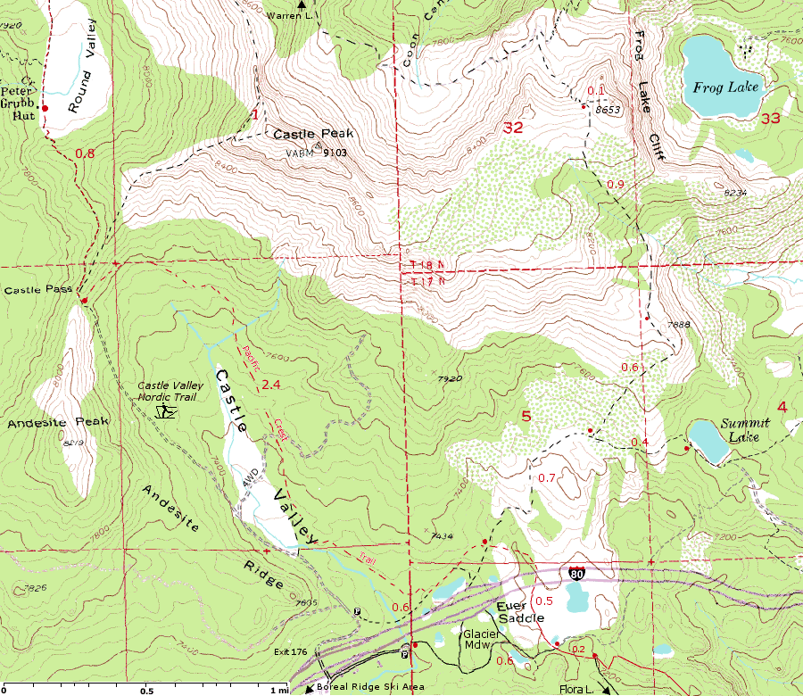
Lola Montez L. - Hole in the ground trail Frog Lake Overlook: 7 mi. (round trip) 7,200-8,653 1,450 gain
Note: Distance to Peter Grubb Hut from the trailhead varies from 4.2 to 4.7 miles depending on what map you use.
Other Maps: Soda Springs Area | I-80 north to Hwy 49 | Donner Summit Trails | Aerial View | Flora Lake  | Basin Pk. Paradise L. Warren L.
Official Trailhead South of I-80:
Take the Boreal/Castle Peak exit from I-80 at Donner Summit. Go east along the
frontage road on the south side of the freeway, pass the Boreal Motel, and park in the PCT
trailhead area at the end of the road (0.3 mi.).
The trail leaves east from the parking area, (300 yds) passes a junction which connects to the
eastbound I-80 rest area and joins the Glacier Meadow Loop Trail, (1/4 mi.) take trail to the right off the
Glacier Meadow Loop Trail, (200 yds) meets the PCT at the edge of a
meadow. Head north on the PCT. After a few hundred yards, the trail enters a
pair of culverts taking you under I-80. Continue north to a four-way trail junction and take the
trail east toward Summit Lake.
Trailhead North of I-80: (Closed in Winter)
Take the Boreal/Castle Peak exit from I-80 (go under I-80 if you were heading eastbound) to
paved frontage road on the north side of I-80.
Turn right. At the end of the paved frontage follow the dirt road north about 1/4 mile toward Castle Valley.
Hike northeast through the trees (A citizen's trail - no beaten path), across the creek until you pick up the PCT.
Go right on the PCT
generally east to the intersection for the Summit L. and Warren L. trail.
Intuitively, this seems shorter than starting from the
south side of I-80 but, because of the cross-country, it takes roughly the same amount of time. It
minimizes your contact with I-80, however, possibly improving your "wilderness" experience.
I hear some people have gotten lost on the citizen's trail because it does ramble a bit.
There are a lot of horse trailers parked on the north side from riders taking the Castle Peak Saddle
I prefer the parking on the south side.
Note: People have been ticketed parking at the rest stop so you should go to one of the Pacific Crest Trailheads (PCT) to park.
Views:
From the top of Castle Peak you have extraordinary views of the Donner Summit region as well as north to Sierra Buttes and south to the peaks of Desolation Wilderness.
From Frog Lake Overlook off of the Warren Lake Trail, you have views of Truckee, Donner Summit, Castle Peak, Sierra Buttes.
The views from Andesite Peak are as grand as anywhere else in the area. In fact, being able to see Castle Peak in the 360-degree panorama might be more interesting than standing on it.
Donner Summit Sno-Park:
This area is an official California Department of Parks and Recreation Sno-Park - Sno-Parks are snow-cleared parking lots, with sanitation facilities, that provide direct access to popular cross country ski trails, snowmobile routes, and snow play areas.
Limited snow play at east end of Sno-Park (main section is private property). Very popular cross-country ski area; some snowmobiling. Crowded on weekends. Avalanche and rock fall danger on steeper slopes of trails. Capacity 100 cars. Information: US Forest Service (530) 587-3558
Frog Lake Overlook: 7 miles round trip
Wandering in level forest for first half, then relentlessly up. Spectacular views for
most of the last third (Truckee, Donner Summit, Castle Peak, Sierra Buttes)
Summit Lake: 4 miles round trip
There are a few campsites here, but the ambience is not conducive to a wilderness experience because of some I-80 traffic noise. (I-80 is 0.4 mi. to the south.)
Some guides say there may be four wheel drive (4WD) traffic from a road coming in from the east, but no one has seen any vehicles in the last few years.
Warren Lake: 15 miles round trip
Warren Lake is not particularly outstanding, however, the rout to it is. The trail contains a 3-mile rambling traverse of a multifaceted, glaciated basin that is reminiscent of Washington's North Cascades, conveying a sense of unbridled wilderness not found in most of the Tahoe Sierra.
Source: "The Tahoe Sierra: A Natural History Guide to 112 Hikes in the Northern Sierra"
d
Peter Grubb Hut:
Peter Grubb Hut sleeps 15 comfortably and serves as a convenient base for winter recreationists to explore Castle Peak, Basin Peak, and Sand Ridge Lakes. Contact the Sierra Clubs Clair Tappaan Lodge for reservations.
Castle Valley Nordic Trail:
3 mi. Intermediate to Advanced
A marked nordic ski trail begins at the Castle
Peak/Boreal Interchange at Donner Summit and follows
the road approximately .25 mile to an intersection.
From this intersection nordic skiers can take the trail to
the north which continues up Castle Valley and over
Castle Pass. From there an unmarked trail continues on
to the Peter Grubb Hut. For the experienced skiers
more difficult routes continue on to Castle or Basin
Peaks.
Links:
Snowshoe trails at Gorp
Tahoe NF Winter Recreation
Emergency Contacts
last updated 23 Jan 2007
|  Donner Summit
