Under Construction 
 2021
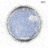
7,500 active satellites in LEO as of September 2021
2021
7,500 active satellites in LEO as of September 2021
There are at least 128 million pieces of debris in LEO. Of those, around 34,000 are over 4 inches (10 centimeters), according to the There are already at least 128 million pieces of debris in LEO. Of those, around 34,000 are over 4 inches (10 centimeters), according to the Natural History Museum in London, LiveScience
Almost half are inactive GeospacialWorld
| Type | Altitude (mi) | Speed MPH | period | use |
| Clouds | 1-4 | | |
| Commercial Airplanes | 7 | 570 | |
| SR-71 Blackbird | 15 | 2,275 | |
| Highest manned baloon | 21 | | |
| SpaceShipOne rocket plane | 70 | 2,375 | |
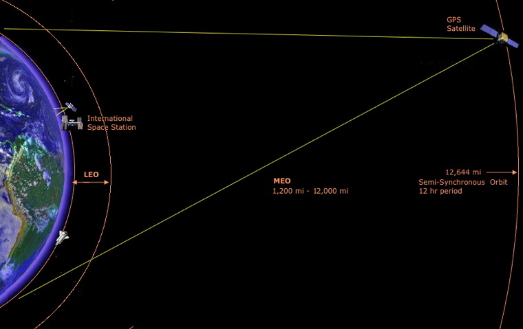
| Low Earth Orbit LEO | 50-1200 | 17,000 | 90 min | weather, reconnaissance (spy) or Earth-mapping |
| Space Shuttle | 190 - 330 | 17,000 | |
| International Space Station (ISS) | 173 - 286 | | 92 min |
| Hubble Telescope | 370 | | |
| Medium Earth Orbit MEO | 1,200-12,000 | | 2 - 12 hrs | Navigation, |
GPS Satellites
Semi-Synchronous Orbit SSO | 12,644 | | 12 hrs |
Geostationary orbit
High Earth Orbit HEO | 23,300 | 6,870 | 24 hrs | telecommunications, Satellite TV |
Geostationary orbit
High Earth Orbit HEO | 23,300 | 6,870 | 24 hrs | telecommunications, Satellite TV |
| James Webb Space Telescope | 1 million | | 365 days | Target launch date is 2018. It is 4 times the distance of the moon at a Lagrange point relative to the sun and earth so they stay in the same positions relative to each other. Studies the study the Universe in infrared light.
See The James Webb Space Telescope Science
|
| Moon | 225,622 - 252,088 | | 27 days |
The earth's diameter is 7,926 miles.
Large image at Wikipedia
The advantage of LEO's is lower power required for radio transmitters and more detailed viewing for weather and reconnaissance.
There is also less time delay.
The disadvantage is the small fast moving footprint for ground radio reception.
You can only get direct radio signals for about 10 minutes for the International Space Station (ISS) while a given GPS satellite will be accessible for 5-10 hours.
In some cases constellations of multiple satellites are required.
Some satellites (e.g. Search and Rescue LEOSAR) have a wider angle of coverage for a larger footprint.
Polar Earth Orbits can be positioned at different altitudes above the Earth's surface depending on their uses. Polar orbit satellites are most often used as weather, reconnaissance (spy) or Earth-mapping satellites. They are typically at LEO altitudes.
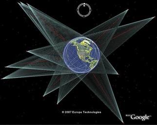 GPS satellites are between 6,000 and a Semi-Synchronous Orbit with a period of 12 hrs at 12,644 mi.
Objects in LEO encounter atmospheric drag in the form of gases in the thermosphere (approximately 80-500 km up) or exosphere (approximately 500 km and up).
The Joint Space Operations Center, part of United States Strategic Command (formerly the United States Space Command), currently tracks more than 8,500 objects larger than 10 cm in LEO,[4] however a limited Arecibo Observatory study suggested there could be about one million objects larger than 2 millimeters,[5] which are too small to be seen from the ground.
See Space junk by wayne@sparkleberrysprings.com
Glossary:
Satellite Orbits
OSDPD - Office of Satellite Data Processing and Distribution at NOAA
Cospas-Sarsat is an international satellite-based search and rescue (SAR) distress alert detection and information distribution system, established by Canada, France, the United States, and the former Soviet Union in 1979.
Links:
Orbits at NASA.gov
Satellite - Software: Satellite tracking
Live Real Time Satellite And Space Shuttle Tracking And Predictions
X XM & Sirius in Orbit
GPS in technology
last updated 1 June 2014
|
 Science