Recreation
Jeep Trails Rubicon Jeep Trail
Recreation
Jeep Trails Rubicon Jeep Trail
| Don's Home
Recreation
Jeep Trails Rubicon Jeep Trail
| Contact |
|
Off-Road Vehicles, clubs, trips... |
Jeep Configuration | Trails | Trip Checklist | Jeeps
Contents: Description | Aerial Photo | Maps | History | Books | Organized Trips | Directions | Organizations

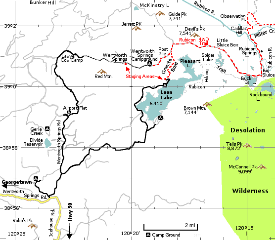
Glenn Wakefield describes the trail as follows: The original trail went from Georgetown thru Wentworth Springs to Tahoma at Lake Tahoe. Loon Lake is a more popular staging area now. The trail is 15 miles long from the staging areas at Loon lake to the Tahoma staging area, which is 2.5 mi. from Hwy 89 at Lake Tahoe. It can be completed in two days (10 or more hours), but three is recommended. From Wentworth Springs the axel-busting trail goes over an outcrop of rough basalt lava known as the "Post Pile" or "Devil's Playground".
From Loon Lake the trail goes over Granite Bowl before it connects with the trail from Wentworth Springs. Jeeps with modifications listed below are recommended, however you can make it with a minimum of 2 1/2 in. lift and 32" tires or even 4x4 pickups by taking bypasses around the more difficult spots. You should go with someone who has experience on the trail the first time.
From Georgetown it is 51.5 miles to Loon Lake and 55 mi. to Wentworth Springs. Jeep Jamboree trips start at Georgetown. | |||
Region Map: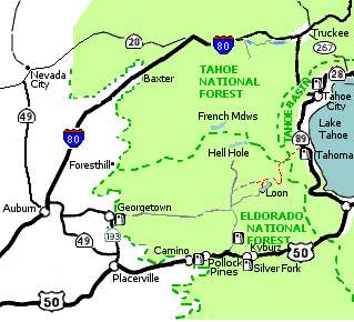 zoom out | Map at rubicon-trail.com |
Where to get Parts at rubicon-trail.com Where to get gas All phone (530) Ice House Resort 293-3321 7-9 wknds. Georgetown - Gas & Go 333-1586, Murchie's Garage 333-4344 Homewood - Obexers Marina 525-7962 | Tahoe City - Chevron 583-0211 Kyburz - Silver Fork Store - 293-3172 Pollock Pines - Crystal View Station 644-6041 Towing: Truckee: Dependable Tow 587-5292 See Distances below. | ||
. Adapted from "Guide to Northern California Backroads & 4-Wheel Drive Trails". Other map links below.
Wentworth Springs & Loon Lake Lake Tahoe
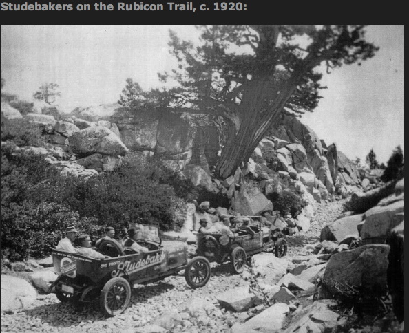
Some the best known obsticles are: See Directions below. History: (http://www.co.el-dorado.ca.us/Rubicon/About.htm) Originally a Native American trail connecting the Sacramento Valley and Lake Tahoe, the Rubicon Trail was re-discovered by European immigrants in the 1840s. In 1856, the federal governmenet established the Rubicon as an official wagon trail, because it is the lowest pass (7,100') and is a more gradual climb than Echo and Donner summits. By the 1890s, the trail had become an actual road (by the standards of the day) and was used to reach the Rubicon Mineral Springs Resort and Hotel. The first car into Rubicon Springs arrived in 1908, driven by a woman from Lake Tahoe. This historic drive received quite a bit of publicity from the San Francisco newspapers. However, when the Rubicon Springs Hotel closed in the late 1920s, the road fell into disuse. In 1939, El Dorado Co. rebuilt the bridge across the Rubicon River and in 1947 replaced the log bridge with a steel bridge. The route has been used by 4-wheel drive vehicles since the early 1950s and has become one of the most famed, 4-wheel drive trails in the world. Mark Smith, The "Godfather of Rockcrawling" started exploring the trails out of Georgetown in 1951. When he first ran the Rubicon in 1951, it was, he remembers, mostly a cobblestone road. He says, "You could do the whole thing in a day." Says Smith, "It's much more difficult than it ever used to be. A lot of that's because of vandalism, people rolling big rocks down in the trail. In 1952 Smith and several other residents of Georgetown held a meeting to discuss the possibility of an organized jeep tour from Georgetown to Lake Tahoe, via the Rubicon Trail. On August 29, 1953, 55 jeeps with 155 enthusiastic participants left Georgetown on a two day trip that is now known as "Jeepers Jamboree 1." The last weekend of July each year, four-wheelers follow the tradition of these "pioneers." (In 2003 there were 800 vehicles. See below.)
At fourwheeler.com/eventcoverage they say: So Little Sluice is blocked off, and the trail takes a bypass. Big Sluice, that heart-in-your-throat downhill that's studded with Jeep-sized rocks and lined by boulders on one side and a cliff on the other--well, that seemed tamer than I'd ever seen it. Hey, none of it's easy, and as I constantly reminded myself, this trail changes every year, not only because of the attentions it gets from various rock rollers, but also because of the incredibly severe winters that descend upon the Sierra Nevadas. Smith and a group of investors bought the property that holds the Rubicon Springs in 1985. These days, what was a beautiful but primitive campsite holds a caretaker's cabin plus several semi-permanent buildings used for cooking, feeding and watering the crowds that come through on the Jamboree trips. On July 13, 2004, the El Dorado County Board of Supervisors declared a state of local emergency concerning the use of Spider Lake-Little Sluice. The area is south of and adjacent to the Rubicon Trail. A significant amount of human fecal waste has been deposited within this area creating a health and safety threat to the users of the Rubicon Trail and adjacent lakes and streams, which in turn flow into the American River Watershed. The area reopened November 10, 2004, however we're asking that everybody stay at least fifty feet from the lake and pack ALL waste out. In the 1980's Planning for a basin-wide effort to improve the water quality entering Lake Tahoe included water shed improvements along the McKinney-Rubicon Road. These improvements were funded by State of California Bond Acts, OHV Trust Fund dollars (Greensticker funds as some of us refer to it) as well as Placer County. The improvements along this route included the construction of rolling dips, water bars, rock-lined ditches, sediment basins, hardened water crossings, and rockwork structures as well as the bridge over McKinney Creek just below the staging area. These improvements remove sediment and decrease vehicle interaction with watercourses. As a provision of receiving the funding, Placer County agreed to maintain these improvements for a minimum twenty-year period (1986-2006). In 2001 Del Albright forms Friends of the Rubicon (FOTR), with the help of the Pirates of the Rubicon, BlueRibbon Coalition, CA4WDC, CORVA, AMA, United FWDA and several individuals. FOTR is an informal coalition of groups and individuals dedicated to keeping the Rubicon Trail open and available to all recreationists. Working with Placer County, El Dorado County, the USFS, private businesses, many organized recreation groups, and other land management agencies.
In 2004, the Rubicon Trail Foundation (Inc.) was set up to help the Rubicon Trail and Friends of the Rubicon. It is separate from FOTR, but supportive of our efforts to keep the trail alive and well.
See:
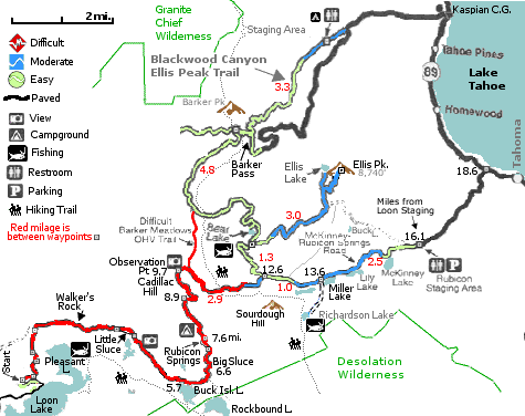
Conditions: On May 23, 2004 there were 2-3' snow drifts on the trail as you approached Miller Lake and 6' drifts beyond it. The trail opened even later in 2005 which had double the normal snowfall.
Vehicle requirements:
Communications:
Books: Organizations and Trips:There are three main organizations which provide commercial Rubicon trips. Prices are for 2005 and may be higher now. In addition local clubs have trips for their members.
* Jeep Jamboree USA Trips (530) 333-4777 - Commercial trips across the country. Private trips (they provide the jeep) for $1,850/person 2 people.
* Jeepers Jamboree Inc., (530) 333-4771 - , they sponsor the oldest (Started in 1953) and largest trips (800 vehicles in 2003).
Jeepers Jamboree: last week in July. - 4 day $305, 3 day $285. A description of the 2003 Jeepers Jamboree at fourwheeler.com says: "There was a lot of drinking, drugs, loud music and incredibly poor stewardship of the land."
Jeep Jamboree: first week in Aug. - 3 day $285. They have a permit from El Dorado County for exclusive use of the trail during a 10 day period then.
* Adventurous off-road trips on the Rubicon Trail by Harald Pietschmann Vehicle requirement summary at the Jeep Configuration page.
Organizations:
Blueribbon Coalition - The BlueRibbon Coalition champions responsible use of public lands for the benefit of all recreationists.
Directions to Loon Lake and Wentworth Springs:
To Wentworth Springs: (The original Rubicon Trail route). Travel another 5 or 6 miles. You'll go past the Gerle Creek Campground and the Airport Flat Campground. You'll see a sign for Bunker Hill Lookout and McKinstry Lake (to the right). Take this off-shoot paved road. It won't be paved long. Just before the pavement ends you'll go past Lawyer Cow Camp (some old buildings still standing there), and shortly you'll encounter a faint, narrow road off to the right. That's the Wentworth Springs Road. You'll cross a creek right off the bat, but the road is in pretty good shape for a while. Mostly 2WD stuff at this point. Travel a few more miles and you're at Wentworth Springs Campground, with toilet and campfire pit.
From Georgetown:
From Tahoe:
From Rubicon Springs: (approximate calculation - I haven't measured it) Homewood (gas) 14 mi. (Marina price is 50% higher) Ice House Resort (gas) 31 mi. Silver Fork (Hwy 50) 47 mi. Pollock Pines (Hwy 50) 47 mi. Georgetown (gas) 48 miTrail Descriptions: The Rubicon 4WD Trail by Glenn Wakefield www.off-road.com/4x4web/travels/rubicon.html Del Albright's page 1996 Rubicon Jeepers Jamboree at off-road.com www.rubicon-trail.com/ History of the Trail www.expeditionswest.com/
Organizations:
Maps:
Georgetown Information: History of the Rubicon Name: There is Rubicon bay, peak and river. Early settlers named the Rubicon river after its counterpart in Europe - a small river between France and Italy. But "Rubicon" has more significance than just the name of two rivers. There is a reason why wines and companies bear the name Rubicon.
Julius Caesar put the name Rubicon in all history books and anyone struggling with Latin in school probably still remembers the Rubicon in connection with Caesar's famous words "alea iacta est!" - "the die is cast!"
The significance of Caesar exclaiming "alea iacta est" was that by crossing the Rubicon, he was at the point of no return; he was declaring war on Rome.
See Also:
Pictures:
| |||