 Places
California
Fires
2020 North Central California Fires
Places
California
Fires
2020 North Central California Fires
| Don's Home
Places
California
Fires
2020 North Central California Fires
|
| See also: California Fire History | 2021 North Central California Fires | Air Quality |
As of November 1st about 4,149,345 million acres, an area the size of the state of Connecticut, in California have burned from over 8,834 wildfires since the beginning of the year.*
To date, the total number of fatalities from these fires is 31, and over 10,488 structures have been damaged or destroyed.
* Numbers include fires CAL FIRE responded to and US Forest Service fires. Some are as small as 10 acres.
On October 12th there were 23 major wildfires burning.
By November 1st there were 7 .
Three of the 4 largest fires in California history (since 1932) and 5 of the top 20 occurred in 2020.
California historically experiences some of the most devastating wildfires in the months of September and October.
From the begining of the year until September 12th there had been fires of over 100 acres in 47 of California's 58 counties. Only Alpine, Amador, Colusa, Del Norte, Inyo, Modoc, Orange, Placer, Sacramento, San Francisco, and Sutter had no fires over 100 acres.
Source: 2020 Statewide Fire Summary | CAL FIRE
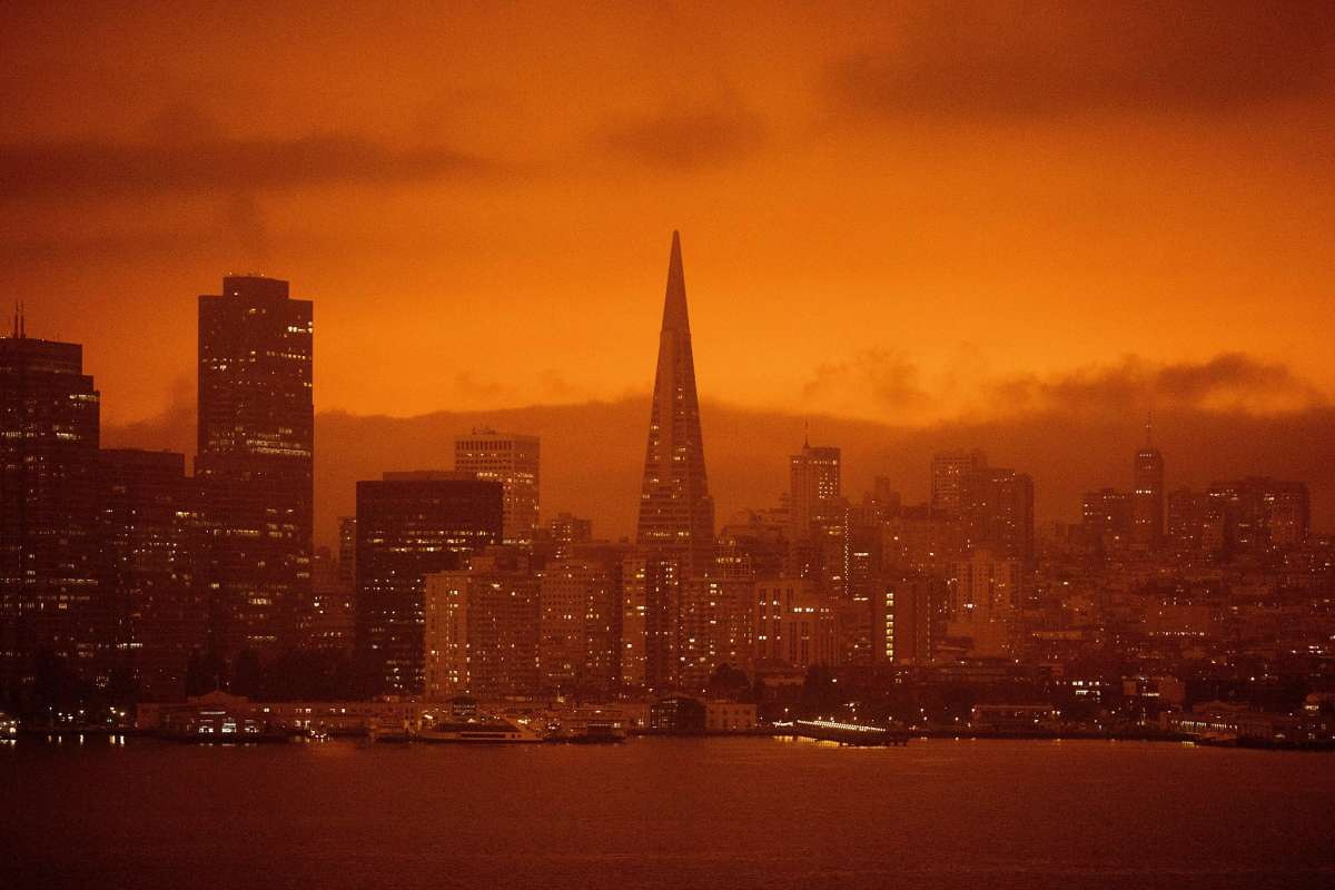
On September 9th the LA Times tweeted "From San Francisco to Yosemite, social media was filled with images of ominous red and orange skies and smoky air." This picture was taken during the day.
Ashes were falling all around the Sacramento Valley.
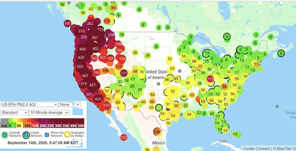
Air quality was listed as unhealthy starting on Labor Day Sept 7 for San Francisco, the East Bay and Peninsula, Redwood City, San Mateo, ... because of the Smoke. Street lights were left on all day in San Francisco.
See air quality below:
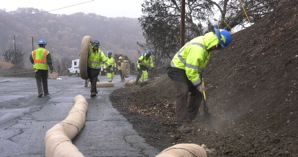 Watershed hazard mitigation underway in @CountyofNapa
around #LakeBerryessa. Toxic debris from the #LNUfire can pollute waterways. So
@Cal_OES and the #CCC are working to protect our drinking water. WATCH THIS YouTube
Watershed hazard mitigation underway in @CountyofNapa
around #LakeBerryessa. Toxic debris from the #LNUfire can pollute waterways. So
@Cal_OES and the #CCC are working to protect our drinking water. WATCH THIS YouTube
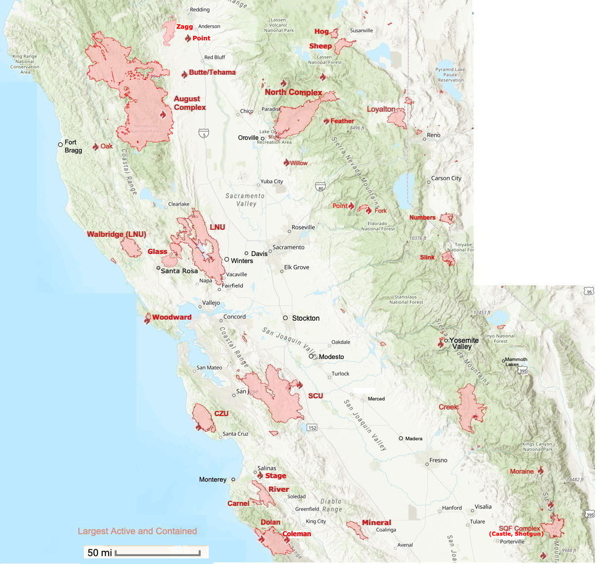
Northern California Map
The map shows just north central California but the data below includes the whole state.
See Cal Fire's Active fire list for a map with all fires.
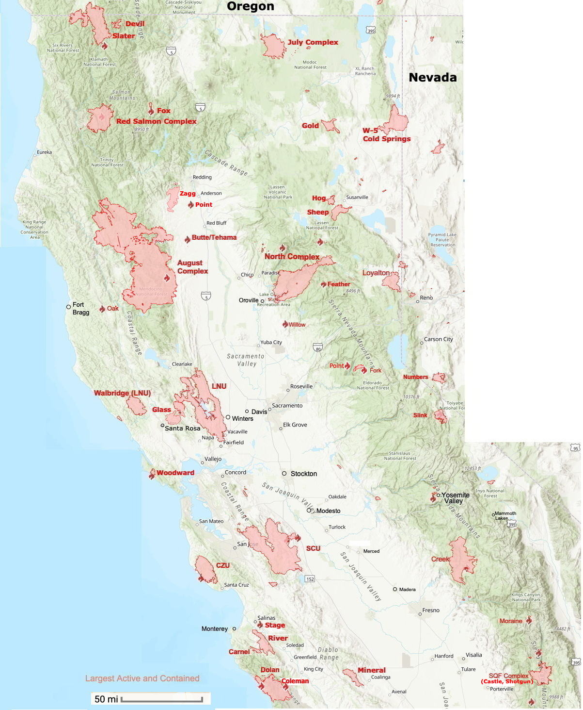 Map to Oregon border
| Name | Start Date | Counties | Acres | Containment 9/15 |
|---|---|---|---|---|
| Active | ||||
| New | ||||
| Largest | ||||
| August Complex (includes Doe Fire) | 08/16/20 | Mendocino and Humboldt | 1,032,264 | 91% |
| North Complex Fire | 08/18/20 | Plumas, Butte and Yuba | 318,724 | 83% |
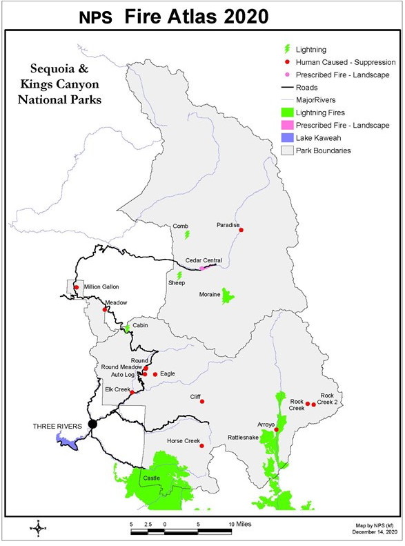
| SQF Complex Fire (Includes Castle Fire and Shotgun Fire) The Castle fire destroyed 10-14% of the worlds sequoia population. of the world's mature giant sequoia population. | 08/21/20 | Tulare | 168,095 | 73% |
| Point Fire El Dorado NF | Placer | 93 | 40% | |
| Slater/Devil Fire | Siskiyou | 156,688 | 85% | |
| Coleman (Dolan) | 10/18/20 | Monterey Fort Hunter Liggett | 500 | 0% |
| Contained >100,000 acres | ||||
| LNU Lightning Complex (includes Hennessey, Gamble, 15-10, Spanish, Markley, 13-4, 11-16, Walbridge) | 08/17/20- 10/1/20 | Napa, Sonoma, Lake, Yolo and Solano | 363,220 | 100% |
| Glass, Boysen, Shady | 09/27/20 | Sanoma, Napa | 67,484 | 100% |
| SCU Lightning Complex | 08/18/20- 10/1/20 | Santa Clara, Alameda, Contra Costa, San Joaquin and Stanislaus | 396,624 | 100% |
| Red Salmon Complex | 07/27/20 | Humboldt, Siskiyou, and Trinity | 104,587 | 100% |
| Dolan Fire | 08/19/20 | Monterey | 128,416 | 100% |
| Contained by county | ≥ 1,000 acres | ||||
| SCU 396,624 acres | Santa Clara, Alameda, Contra Costa, San Joaquin and Stanislaus | |||
| Salt Fire | 08/18/20 | Calaveras | 1,789 | 100% |
| Walker Fire | 06/16/20 | Calaveras | 1,455 | 100% |
| SCU 396,624 acres | Santa Clara, Alameda, Contra Costa, San Joaquin and Stanislaus | |||
| Numbers Fire | 07/06/20 | Douglas, NV | 18,342 | 100% |
| Fork Fire | 09/08/20 | El Dorado | 1,667 | 63% |
| Creek Fire | 09/04/20 | Fresno and Madera | 346,477 | 100% |
| Mineral Fire | 07/13/20 | Fresno | 29,667 | 100% |
| Bullfrog Fire | 09/12/20 | Fresno | 900 | 100% |
| Hills Fire | 08/15/20 | Fresno | 2,121 | 100% |
| Butte/Tehama/Glenn Lightning Complex (Tehama/Glenn Zone) | 08/19/20 | Tehama and Glenn | 19,609 | 100% |
| Bena Fire | 07/01/20 | Kern | 2,900 | 100% |
| LNU 363,320 acres | Napa, Sonoma, Lake, Yolo and Solano | |||
| North Fire | 08/02/20 | Lassen | 6,882 | 100% |
| W-5 Cold Springs | 08/18/20 | Lassen | 84,817 | 100% |
| Gold | 7/20/20 | Lassen | 22,634 | 100% |
| Hog | 7/18/20 | Lassen | 9,564 | 100% |
| Woodward Fire | 08/18/20 | Marin | 4,929 | 97% |
| Oak Fire | 09/07/20 | Mendocino | 1,100 | 100% |
| Pass Fire | 06/28/20 | Merced | 2,192 | 100% |
| Blue jay | 07/24/20 | Mariposa | 4,427 | 100% |
| River Fire | 08/16/20 | Monterey | 48,088 | 100% |
| Carmel Fire | 08/18/20 | Monterey | 6,905 | 100% |
| LNU 363,320 acres | Napa, Sonoma, Lake, Yolo and Solano | |||
| Sheep Fire | 08/22/20 | Plumas | 29,570 | 100% |
| Coyote Fire | 07/15/20 | San Benito | 1,508 | 100% |
| India Fire | 06/09/20 | San Diego | 1,100 | 100% |
| Crews Fire | 07/05/20 | Santa Clara | 5,513 | 100% |
| SCU 396,624 acres | Santa Clara, Alameda, Contra Costa, San Joaquin and Stanislaus | |||
| CZU Fire | 08/16/20 | Santa Cruz and San Mateo | 86,509 | 100% |
| Zagg | 09/27/20 | Shasta | 56,335 | 100% |
| Loyalton Fire | 08/14/20 | Sierra | 47,029 | 100% |
| Feather Fire | 07/20/20 | Sierra | FI | |
| Fox Fire | 09/11/20 | Siskiyou | 1,937 | 100% |
| Schoolhouse Fire | 09/09/20 | Siskiyou | 45 | 100% |
| Shackleford Fire | 09/11/20 | Siskiyou | 50 | 100 |
| Quail Fire | 06/06/20 | Solano | 1,837 | 100% |
| LNU 363,320 acres | Napa, Sonoma, Lake, Yolo and Solano | |||
| Butte/Tehama/Glenn Lightning Complex (Tehama/Glenn Zone) | 08/19/20 | Tehama and Glenn | 19,609 | 100% |
| Moc Fire | 08/20/20 | Tuolumne | 2,857 | 100% |
| Wolf | 08/11/20 | Tuolumne | 1,092 | 100% |
| Willow Fire | 09/09/20 | Yuba | 1,311 | 100% |
| LNU 363,320 acres | Napa, Sonoma, Lake, Yolo and Solano | |||
| Name | Start Date | Counties | Acres | Containment |
|---|---|---|---|---|
| Active | ||||
| New | ||||
| Snow | 9/17/20 | Riverside | ||
| Largest | ||||
| Lake Fire | 08/12/20 | Los Angeles | 31,089 | 96% |
| Bobcat Fire | 09/06/20 | Los Angeles | 29,245 | 6% |
| Valley Fire | 09/05/20 | San Diego | 17,665 | 79% |
| El Dorado Fire | 09/05/20 | San Bernardino and Riverside | 17,598 | 44% |
| Pond Fire | 08/01/20 | San Luis Obispo | 1,962 | 99% |
| Moraine Fire | 08/21/20 | Tulare | 575 | 70% |
| Rattlesnake Fire | 09/03/20 | Tulare | 2,078 | 0% |
| SQF Complex Fire (Includes Castle Fire and Shotgun Fire) | 08/21/20 | Tulare | FI-Federal Incident | |
| Apple Fire | 07/31/20 | Riverside | FI | |
| Contained >1,000 acres | ||||
| Stagecoach Fire | 08/03/20 | Kern | 7,760 | 100% |
| Interstate 5 Fire | 05/03/20 | Kings | 2,060 | 100% |
| Ranch 2 Fire | 08/13/20 | Los Angeles | 4,237 | 100% |
| Soledad Fire | 07/05/20 | Los Angeles | 1,525 | 100% |
| Range Fire | 05/27/20 | San Luis Obispo | 5,000 | 100% |
| Branch Fire | 07/28/20 | San Luis Obispo | 3,022 | 100% |
| Soda Fire | 06/10/20 | San Luis Obispo | 1,672 | 100% |
| Holser Fire | 08/17/20 | Ventura | 3,000 | 100% |
See Fire Map above.
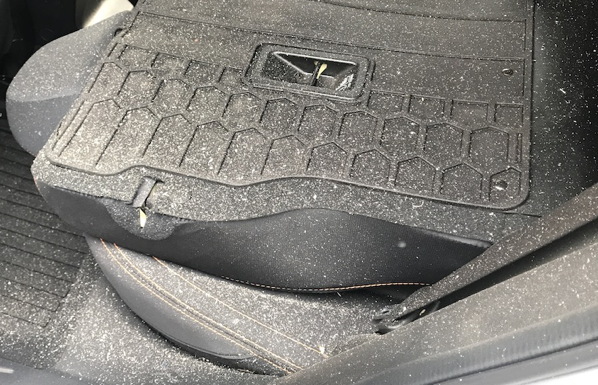 I left my car windows open a crack because of the 108° temperature and it was covered with ash from the fires in the morning.