 Places
NE NJ & NY City
Sourland Mountain Preserve
Places
NE NJ & NY City
Sourland Mountain Preserve
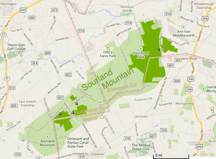
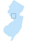 The 90-square-mile Sourland region is home to the largest contiguous forest in Central New Jersey. The sparsely populated area includes parts of Somerset, Hunterdon and Mercer counties, and encompasses a complex ecosystem of forest, wetlands and grasslands.
It contain 25,000 acres of contiguous forest, 7,500 acres of wetlands and some 18,000 acres of agricultural lands in active production. Groundwater recharge and various streams in the Sourlands supply the Delaware & Raritan Canal, which provides drinking water to over 1.2 million New Jersey residents.
Its mosaic of habitats is home to an incredibly rich diversity of animal and plant species, many rare or endangered. The forest is especially important as a breeding area for migratory songbirds, particularly those who nest only in large wooded areas.
Threatened and endangered animal species include the barred owl, bobcat, Cooper’s hawk, grasshopper sparrow, savannah sparrow, upland sandpiper and wood turtle. In addition, the Sourlands serves as a stopover area for migratory birds that travel between South America and the boreal forests of Canada and for breeding, migratory birds that travel from New Jersey to Central America. The area also supports a large population of forest interior birds such as scarlet tanagers, Kentucky warblers and red-shouldered hawks.
The Sourland Conservancy (formerly Sourland Planning Council) is actively involved in supporting five Townships (Hillsborough, Montgomery, Hopwell, East Amwell & West Amwell) in their efforts to preserve open space and develop protective ordinances and policies for the portions of their towns that lie within the Sourland Mountain region.
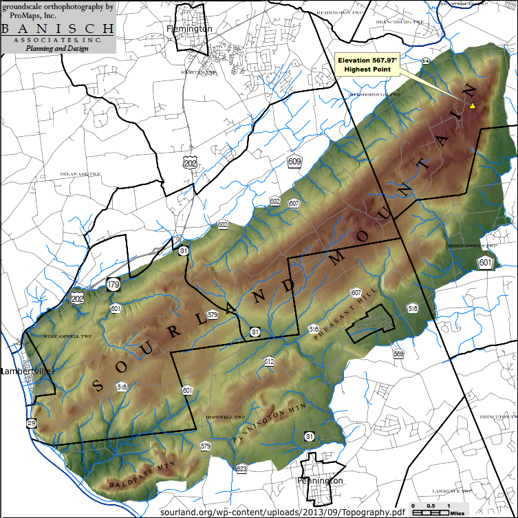
Formed almost 200 million years ago, the rocks of the Sourlands, called diabase or "trap rock," were used to produce railroad ballast, concrete aggregate, and Belgian blocks for road beds. Evidence from quarrying can still be found embedded along the fissures of
some boulders.
The name "Sourlands" is derived from the fact that early settlers found the rocky soils difficult to farm. The limited supply of groundwater saved the forest from destruction by developers. Its woodlands shelter a very rich and diverse native plant community.
The Sourland Mountains are also steeped in mysticism and history. Some say compasses do not work in these hills; others say the mountains are haunted. John Hart, a signer of the Declaration of Independence, hid in these hills during the Revolution. The Lindbergh Estate, the site of the famous baby kidnapping/murder, is near the property.
Notable residents of the Mountain include: playwrights Eugene O'Neill and George Bernard Shaw, aviator Charles Lindbergh, patriot John Hart (signer of the Declaration of Independence), author Richard Preston, and the painter George Bellows.
In March 1932, the Mountain was the scene of the notorious kidnapping and murder of the Lindbergh baby. The Lindberghs had chosen the Mountain for their new home precisely because of its isolation and inaccessibility.
Click on maps below for larger pdf versions.
Somerset County Parks - Sourland Mountain Preserve
Hunterdon County Parks- Sourland Mountain Preserve
Maps:
Map at www.somersetcountyparks.org
Sourland Mountain Nature Preserve | Hunterdon County Dept. of Parks and Recreation
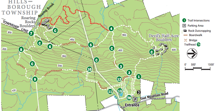
Trail Map
Cross-Country Skiing Map
SOURLANDS: A film by Jared Flesher
Sourlands Preserve | Hidden Trenton
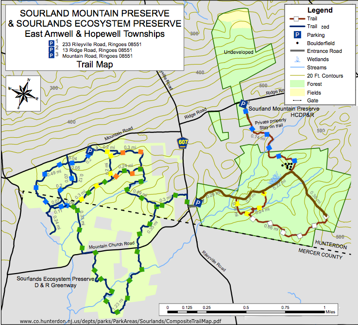
Sourland Mountain Preserve & Sourlands Ecosystem Preserve Composite Maps | www.co.hunterdon.nj.us/depts/parks/ParkAreas/Sourlands/CompositeTrailMap.pdf
Sourland Mountain Preserve - SomersetNew Jersey Trails Association
Maps | Sourland Conservancy
Sourlands [Historical landmarks, Natural Features, Parks and Preserves]
Others: Cycling Map, Bedrock Map, Coutour Map, Drainage Areas Map, Forest Map,
Habitat Map, Seasonal High Water Depth Map, Soil Map, Sub Watershed Map,
Topography Map, Wetlands Map
Articles:
Sourlands Journal - Newsletter of the Sourland Conservancy (formerly Sourland Planning Council)
Spring 2011, Spring 2012, Spring 2013, Autumn 2013
295 acres in the Sourland Mountains was deeded to the Somerset County Open Space program. - December 2013
Hopewell Valley | NJ Conservation Foundation
Sourlands - A Central New Jersey Wilderness - Needs Special Protection | NJaudubon.org
A Vision for the Sourlands | conservationresources.org 2011
Links:
Sourland Conservancy
Images
Sourland Mountain Preserve | Somerset County Park Commission - Map
Sourland Mountain Nature Preserve | Hunterdon County Dept. of Parks and Recreation
Sourland Mountain Preserve | njHiking.com
Sourlands Ecosystem Preserve | www.drgreenway.org
Hiking Sourland Mountain (http://nynjctbotany.org/)
Google for more
Sourland Mountain Preserve Trail review page (bikerag.com)
Sourland Mountain - Wikipedia